Chao Phraya River
| Chao Phraya River (แม่น้ำเจ้าพระยา) | |
|
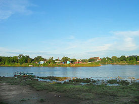
Origin of the Chao Phraya River in Nakhon Sawan
|
|
| Tributaries | |
| - left | Pa Sak River |
| - right | Sakae Krang River |
| Source | Confluence of Ping River and Nan River |
|---|---|
| - location | Pak Nam Pho, Nakhon Sawan province |
| - elevation | 25 m (82 ft) |
| Mouth | |
| - location | Gulf of Thailand, Samut Prakan Province |
| - elevation | 0 m (0 ft) |
| Length | 372 km (231 mi) |
| Basin | 160,400 km2 (61,931 sq mi) |
| Discharge | for Nakhon Sawan |
| - average | 718 m3/s (25,356 cu ft/s) |
| - max | 5,960 m3/s (210,475 cu ft/s) |
|
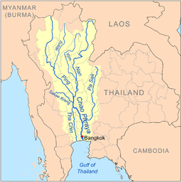
Map of the Chao Phraya River drainage basin
|
|
The Chao Phraya (Thai: (Pronunciation)) is the major river in Thailand, with its low alluvial plain forming the centre of the country. It flows through Bangkok and then into the Gulf of Thailand.
On many old European maps, the river is named Menam or Mae Nam (Thai: ), Thai for "river". James McCarthy, F.R.G.S., who served as Director-General of the Siamese Government Surveys prior to establishment of the Royal Survey Department, wrote in his account, "Me Nam is a generic term, me signifying "mother" and Nam "water," and the epithet Chao P'ia signifies that it is the chief river in the kingdom of Siam."
H. Warington Smyth, who served as Director of the Department of Mines in Siam from 1891 to 1896, refers to it in his book first published in 1898 as "the Me Nam Chao Phraya".
In the English-language media in Thailand, the name Chao Phraya River is often translated as river of kings.
The Chao Phraya begins at the confluence of the Ping and Nan rivers at Nakhon Sawan (also called Pak Nam Pho) in Nakhon Sawan Province. After this it flows south for 372 kilometres (231 mi) from the central plains to Bangkok and the Gulf of Thailand. In Chai Nat, the river then splits into the main course and the Tha Chin River, which then flows parallel to the main river and exits in the Gulf of Thailand about 35 kilometres (22 mi) west of Bangkok in Samut Sakhon. In the low alluvial plain which begins below the Chainat Dam, there are many small canals (khlong) which split off from the main river. The khlongs are used for the irrigation of the region's rice paddies.
...
Wikipedia


