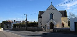
Raharney
|
Raharney Ráth Fhearna
|
|
|---|---|
| Village | |

Raharney Main Street
|
|
| Location in Ireland | |
| Coordinates: 53°31′26″N 7°05′42″W / 53.524°N 7.095°WCoordinates: 53°31′26″N 7°05′42″W / 53.524°N 7.095°W | |
| Country | Ireland |
| Province | Leinster |
| County | County Westmeath |
| Elevation | 75 m (246 ft) |
| Population (2011) | |
| • Total | 227 |
| Irish Grid Reference | N599531 |
Raharney (Irish: Ráth Fhearna, meaning "Fearna's ringfort") is a village in east County Westmeath, Ireland. It has a population of 227.
Raharney is on the R156 road about 18 km (11 mi) from Mullingar and about 67 km from Dublin. It is in the parish of Killucan; the village of Killucan is a further 3 km (1.9 mi) west.
Bus Éireann route 115A provides a commuter link to Dublin via Ballivor, Summerhill and Maynooth with one journey in the morning and an evening journey back Mondays to Fridays inclusive. Until 24 August 2013 (incluive) Bus Éireann route 118 provided a daily commuter service to Dublin via Dunboyne and a daily service to/ from Mullingar.
The village of Raharney has a bridge over the River Deel and is the last settlement of the county on the edge of bogland that separates Westmeath from County Meath. The bridge links the roads that run north-south alongside the River Deel on one side and alongside the bog on the other (road from Delvin and on through Riverdale). The River Deel is a tributary of the Boyne. The roads into the village all slope down towards the river, suggesting that before the bridge was built there was a ford at this point. Looking westward to Mullingar the town is located in the gap between three large lakes. Raharney, therefore, lies on the route of a path of what probably was, in the past, difficult terrain through the midlands. The three east-west roads were the Athboy-Delvin-Mullingar road, the Clonard-Kinnegad-Athlone/Mullingar road and Trim-Raharney/Killucan-Mullingar road.
...
Wikipedia

