Ragnit
| Neman (English) Неман (Russian) |
|
|---|---|
| - Town - | |
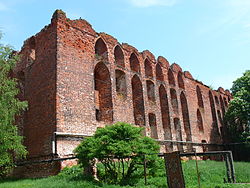
 Castle ruins |
|
 Location of Kaliningrad Oblast in Russia |
|
|
|
|
|
|
|
| Administrative status (as of November 2011) | |
| Country | Russia |
| Federal subject | Kaliningrad Oblast |
| Administrative district | Nemansky District |
| Town of district significance | Neman |
| Administrative center of | Nemansky District, town of district significance of Neman |
| Municipal status (as of February 2013) | |
| Municipal district | Nemansky Municipal District |
| Urban settlement | Nemanskoye Urban Settlement |
| Administrative center of | Nemansky Municipal District, Nemanskoye Urban Settlement |
| Statistics | |
| Population (2010 Census) | 11,798 inhabitants |
| Time zone | USZ1 (UTC+02:00) |
| Founded | 1288 |
| Previous names | Ragnit (until 1946) |
| Postal code(s) | 238710, 238711 |
| Dialing code(s) | +7 40162 |
| on | |
Neman (Russian: Неман), prior to 1946 known by its German name Ragnit (Lithuanian: Ragainė; Polish: Ragneta) is a town and the administrative center of Nemansky District in Kaliningrad Oblast, Russia, located in the historic East Prussia, on the steep southern bank of the Neman River, where it forms the Russian border with the Klaipėda Region in Lithuania, and 130 kilometers (81 mi) northeast of Kaliningrad, the administrative center of the oblast. Population: 11,798 (2010 Census);12,714 (2002 Census);13,821 (1989 Census).
![]() Teutonic Order 1288–1466
Teutonic Order 1288–1466![]() Teutonic Order 1466–1525 (fief of Poland)
Teutonic Order 1466–1525 (fief of Poland)![]() Duchy of Prussia 1525–1657 (fief of Poland)
Duchy of Prussia 1525–1657 (fief of Poland)![]() Duchy of Prussia 1657–1701
Duchy of Prussia 1657–1701![]() Kingdom of Prussia 1701–1871
Kingdom of Prussia 1701–1871![]() German Empire 1871–1918
German Empire 1871–1918![]() Weimar Republic 1918–1933
Weimar Republic 1918–1933![]() Nazi Germany 1933–1945
Nazi Germany 1933–1945![]() Soviet Union 1945–1991
Soviet Union 1945–1991![]() Russian Federation 1991–present
Russian Federation 1991–present
...
Wikipedia

