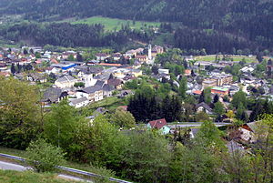
Radenthein
| Radenthein | ||
|---|---|---|
 |
||
|
||
| Location within Austria | ||
| Coordinates: 46°48′N 13°42′E / 46.800°N 13.700°ECoordinates: 46°48′N 13°42′E / 46.800°N 13.700°E | ||
| Country | Austria | |
| State | Carinthia | |
| District | Spittal an der Drau | |
| Government | ||
| • Mayor | Martin Hipp (SPÖ) | |
| Area | ||
| • Total | 89.3 km2 (34.5 sq mi) | |
| Elevation | 746 m (2,448 ft) | |
| Population (1 January 2016) | ||
| • Total | 5,925 | |
| • Density | 66/km2 (170/sq mi) | |
| Time zone | CET (UTC+1) | |
| • Summer (DST) | CEST (UTC+2) | |
| Postal code | 9545 | |
| Area code | 04246 | |
| Vehicle registration | SP | |
| Website | www.radenthein.gv.at | |
Radenthein (Slovene: Radenče ) is a town in Spittal an der Drau District, in the Austrian state of Carinthia.
It is situated in the Gegend valley of the Gurktal Alps (Nock Mountains) range of the Central Eastern Alps, north-east of Lake Millstatt. Radenthein borders on Millstatt in the west and Bad Kleinkirchheim in the east. The municipal area also includes the cadstral communities of Döbriach, Kaning, Laufenberg, St. Peter and Tweng.
The remote forested valley was not colonized until about 1000. A chapel at villam Ratehtim was first mentioned in an 1177 deed, then part of the Millstatt Abbey estates. Since the Middle Ages it had been an iron ore and garnet mining area and the site of a finery forge, even the use of reverberatory furnaces is documented since the late 18th century. When about 1908 an extensive occurrence of magnesite was discovered and the foundation of the "Austro-American Magnesite" mining company led to a large increase in population. The municipality obtained the status of a town in 1995.
The mining company (now RHI AG at Vienna producing refractory materials) is still the main employer. Besides which, there is some hotel and tourist trade in Döbriach on the lakeside of the Millstätter See.
...
Wikipedia


