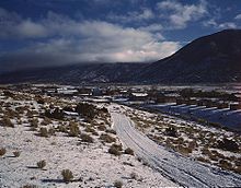
Questa, New Mexico
| The Village of Questa | |
|---|---|
| Village | |

|
|
| Motto: Gateway to the Rio Grande del Norte National Monument | |
 Location of Questa, New Mexico |
|
| Location in the United States | |
| Coordinates: 36°42′23″N 105°35′35″W / 36.70639°N 105.59306°WCoordinates: 36°42′23″N 105°35′35″W / 36.70639°N 105.59306°W | |
| Country | United States |
| State | New Mexico |
| County | Taos |
| Government | |
| • Type | Municipal |
| • Mayor | Mark Gallegos |
| Area | |
| • Total | 5.1 sq mi (13.2 km2) |
| • Land | 5.1 sq mi (13.2 km2) |
| • Water | 0.0 sq mi (0.0 km2) |
| Elevation | 7,461 ft (2,274 m) |
| Population (2000) | |
| • Total | 1,767 |
| • Density | 365.0/sq mi (140.9/km2) |
| Time zone | Mountain (MST) (UTC-7) |
| • Summer (DST) | MDT (UTC-6) |
| ZIP code | 87556 |
| Area code(s) | 575 |
| FIPS code | 35-60870 |
| GNIS feature ID | 0909932 |
| Website | http://questa-nm.com/ |
Questa is a village in Taos County, New Mexico, United States. The population was 1,767 at the 2000 census. Questa is renowned for the beautiful scenery surrounding the small, historic village. The Village offers rare trails into the Rio Grande Gorge, trout fishing for every skill level, and mountain lakes with trails that access the highest reaches of the Sangre de Cristo Mountains overlooking the area. In addition to famously serene camping and stunning hikes, there are many choices for cycling, mountain biking and horseback excursions. Located on the Enchanted Circle Scenic Byway, near the confluence of the Rio Grande and the Red River, Questa offers scenic and serene activities in the protected natural environment surrounding the Village. As the Gateway to the Rio Grande del Norte Monument visitors can enjoy a scenic drive to a stunning overlook of the Red River meeting the Rio Grande in the depth of the Gorge. The Carson National Forest parallels Questa to the east offering high mountain hiking, picnicking, camping and biking. The Columbine Hondo Wilderness and Latir Peak Wildness are found in the Carson National Forest close to Questa. The Red River is undergoing restoration to improve trout habitat with currently a section parallel to Eagle Rock Lake complete.
The Historic San Antonio del Rio Colorado Church in the historic plaza of Questa symbolizing the cultural heart of Questa since the mid-1800s. After suffering a collapse of the west wall in Questa’s historic church the community came together and many of the families that built the church originally are restoring it modern day. Made with beautiful adobe and wood work it was scheduled to be completed mid-2016. The Historic church is open free to the public and anyone of any faith or not of a faith is welcome to come see the jewel of Questa.
With a large Hispanic population, the village economy was historically largely dependent on agriculture and income from a now-closed Chevron molybdenum mine. Many residents also commute to Taos, Red River, and Angel Fire to work in the hospitality industries there.
...
Wikipedia


