Quartzsite
| Quartzsite | |
|---|---|
| Town | |
| Quartzsite, Arizona | |

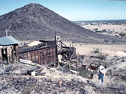
Abandoned mine near Quartzsite
|
|
| Motto: "The Rock Capital of the World" | |
 Location of Quartzsite in La Paz County, Arizona. |
|
| Coordinates: 33°39′54″N 114°13′15″W / 33.66500°N 114.22083°WCoordinates: 33°39′54″N 114°13′15″W / 33.66500°N 114.22083°W | |
| Country | United States |
| State | Arizona |
| County | La Paz |
| Incorporated | 1989 |
| Government | |
| • Mayor | Ed Foster |
| Area | |
| • Total | 36.30 sq mi (94.01 km2) |
| • Land | 36.30 sq mi (94.01 km2) |
| • Water | 0.00 sq mi (0.00 km2) |
| Elevation | 879 ft (268 m) |
| Population (2010) | |
| • Total | 3,677 |
| • Estimate (2016) | 3,644 |
| • Density | 100.39/sq mi (38.76/km2) |
| Time zone | MST (no DST) (UTC-7) |
| ZIP codes | 85346, 85359 |
| Area code(s) | 928 |
| FIPS code | 04-58010 |
| Website | Town of Quartzsite |
Quartzsite is a town in La Paz County, Arizona, United States. According to the 2010 census, the population was 3,677.
Interstate 10 runs directly through Quartzsite and is at the intersection of U.S. Route 95 and Arizona State Route 95 with I-10.
Quartzsite is located at 33°39′54″N 114°13′15″W / 33.66500°N 114.22083°W (33.665116, −114.220913).
According to the United States Census Bureau Quartzsite is all land and has a total area of 36.3 sq mi (94.0 km2).
Quartzsite lies on the western portion of the La Posa Plain along Tyson Wash. The Dome Rock Mountains overlook the town on the west with Granite Mountain on the southwest edge of the town and Oldman Mountain on the northwest. The Plomosa Mountains lie across the La Posa Plain to the east.
The town has a hot desert climate (Köppen BWh) with mild to warm winters from November to March and hot to extreme summers for the remainder of the year. In the middle of summer, Quartzsite is one of the hottest places in the United States and has recorded temperatures as high as 122 °F or 50.0 °C on 28 July 1995.
There is very little precipitation with only 3.51 inches (89.2 mm) falling during an average year, while in May and June more than 80 percent of years do not have measurable rainfall. Since records began in 1928 the wettest month has been September 1939 with 6.16 inches (156.5 mm) which was part of the wettest year with 11.05 inches (280.7 mm) and featuring on September 5 the wettest day with 3.00 inches (76.2 mm). This moisture was due to the remnants of a rare Gulf of California hurricane. The driest calendar year was 1928 with 0.92 inches (23.4 mm). However, between July 2001 and August 2002 as little as 0.45 inches (11.4 mm) fell over fourteen months.
...
Wikipedia
