Quarry Bank
| Quarry Bank | |
|---|---|
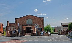
 The Birch Coppice Methodist Church at Quarry Bank |
|
| Quarry Bank shown within the West Midlands | |
| Population | 12,441 (2011.ward.Quarry Bank and Dudley Wood) |
| OS grid reference | SO930860 |
| Metropolitan borough | |
| Metropolitan county | |
| Region | |
| Country | England |
| Sovereign state | United Kingdom |
| Post town | BRIERLEY HILL |
| Postcode district | DY5 |
| Dialling code | 01384 |
| Police | West Midlands |
| Fire | West Midlands |
| Ambulance | West Midlands |
| EU Parliament | West Midlands |
| UK Parliament | |
Quarry Bank is a village in the Metropolitan Borough of Dudley, West Midlands, England, which exists within the Brierley Hill DY5 postal district.
Locally, the name is often pronounced, "Quarry Bonk" (In Black Country Dialect) The Black Country Bugle local newspaper
Originally the area was a rural place, a remote part of the parish of Kingswinford, included in Pensnett Chase. The earliest settlements in Quarry Bank were smallholdings, where an industrial worker such as a nailer lived. Early industrial development took place the early 17th century around the Cradley Forge.
Quarry Bank acquired its own parish status in September 1844. It had an urban sanitory authority and so became an urban district of Staffordshire from 1894. However, in 1934, it amalgamated with the Brierley Hill urban district. This became part of the county borough of Dudley in 1966 and then the Metropolitan Borough of Dudley in West Midlands since 1974.
Quarry Bank has become greatly affected by the adjacent Merry Hill Shopping Centre (which was developed between 1984 and 1989) which has bought high volumes of traffic along the High Street. This has meant demolition of more than 30 homes on the main Merry Hill road in 1997, the closure of the top end of the former High Street (now Sun Street) in 1998, and construction of a new replacement section of High Street to try and cope with traffic.
An unusual feature of Quarry Bank is its long steep High Street, hence "Bank", which slopes from the bottom end where it meets the neighbouring town of Cradley to the top at the junction with Thorns Road. Clinging to the hillside and varying from very steep to almost flat, it has changed little, except for modernisation of shop fronts. Major retail chains have bypassed the town, leaving just small independent traders and public houses.
...
Wikipedia

