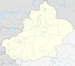
Qitai
|
Qitai County 奇台县 • ٿِتَیْ ﺷِﯿًﺎ • گۇچۇڭ ناھىيىسى (Chinese) • (Uyghur) • (Xiao'erjing) |
|
|---|---|
| County | |
 Location of Qitai (pink) in Changji Prefecture (yellow) and Xinjiang |
|
| Location in Xinjiang | |
| Coordinates: 44°01′N 89°35′E / 44.017°N 89.583°ECoordinates: 44°01′N 89°35′E / 44.017°N 89.583°E | |
| Country | People's Republic of China |
| Region | Xinjiang |
| Autonomous prefecture | Changji |
| Township-level divisions | 6 towns 6 townships 3 ethnic townships |
| County seat | Qitai Town (奇台镇) |
| Area | |
| • Total | 16,641 km2 (6,425 sq mi) |
| Population | |
| • Total | 230,000 |
| • Density | 14/km2 (36/sq mi) |
| Time zone | China Standard (UTC+8) |
| Area code(s) | 0994 |
Qitai County (simplified Chinese: 奇台县; traditional Chinese: 奇台縣; pinyin: Qítái xiàn; Xiao'erjing: ٿِتَیْ ﺷِﯿًﺎ; Uyghur: گۇچۇڭ ناھىيىسى, Гучуң Наһийиси, ULY: Guchung Nahiyisi, UYY: Guqung Nah̡iyisi?), historically known as Gucheng (古城), is a county in the Xinjiang Uyghur Autonomous Region of China under the administration of the Changji Hui Autonomous Prefecture. It covers an area of 16,641 square kilometres (6,425 sq mi) and as of the 2002 census[update] had a population of 230,000.
Qitai County's county seat is in Qitai Town. Gucheng Township is nearby.
...
Wikipedia

