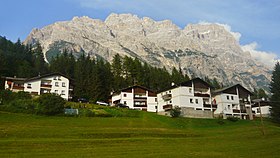
Punta Sorapiss
| Sorapiss | |
|---|---|
 |
|
| Highest point | |
| Elevation | 3,205 m (10,515 ft) |
| Prominence | 1,085 m (3,560 ft) |
| Coordinates | 46°30′N 12°13′E / 46.500°N 12.217°ECoordinates: 46°30′N 12°13′E / 46.500°N 12.217°E |
| Geography | |
| Location | Veneto, Italy |
| Parent range | Dolomites |
Sorapiss, also referred to as Sorapis or Punta Sorapiss, is a mountain in the Dolomites within the Veneto region of northern Italy. Situated in the comune of Cortina d'Ampezzo, it has an elevation of 3,205 metres (10,515 ft). In its vicinity is a mountain pass of the same name, as well as Lago di Sorapiss (Sorapiss Lake), at the foot of the mountain.
Sorapiss, with its huge perpendicular faces, forms part of the mountainous backdrop to the resort town of Cortina, situated roughly 9 kilometres (5.6 mi) to the southeast of the town. The limestone dolomite formations, which are irregular, rugged and sharp-edged peaks, are part of the Eastern Alps. The Cristallo group lies to the north past the Passo Tre Croci, and its southern neighbour is the Antelao. A path to Sorapiss starts at Passo Tre Croci and continues along an easy slope, reaching the refuge at the base of the Sorapiss range, close to Lago di Sorapiss, which is at an elevation of 1,923 metres (6,309 ft).
The elevation of Sorapiss is 3,205 metres (10,515 ft). The mountain has three ridges: a central ridge, a southern ridge, which is the part of the mountain that can be seen from Cortina, and, beyond a high pass and little to the west, a northern ridge that culminates in the skiing area of Mount Faloria. There are three glaciers on the mountain's slopes, although these have been melting considerably in recent years. Lago Sorapiss, at the foot of the mountain, is a glacial lake at an elevation 1,925 metres (6,316 ft).
There are three refuges in the vicinity: Rifugio Tondi di Faloria at 2,327 metres (7,635 ft),Rifugio Alfonso Vandelli at 1,926 metres (6,319 ft) and Rifugio San Marco. Rifugio Alfonso Vandelli was built by Austrians in 1891 on the banks of Lago di Sorapiss. In 1895 it was destroyed by an avalanche, but was rebuilt the following year in a more sheltered spot. At the end of World War I in 1918, Cortina d'Ampezzo became part of the Kingdom of Italy (1918) and the refuge became the property of the CAI (Club Alpino Italiano) of Venice. In 1924, thanks to a donation by Cesare Luigi Luzzati, a new refuge was built. A fire destroyed it completely in 1959, and it was again reconstructed; the current shelter was opened on 18 September 1966 and was named after the president of the CAI of Venice, Alfonso Vandelli.
...
Wikipedia

