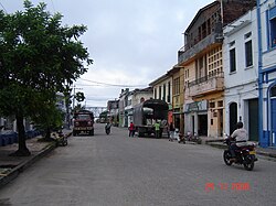
Puerto Berrio
| Puerto Berrío | |||
|---|---|---|---|
| Municipality and town | |||
 |
|||
|
|||
 Location of the municipality and town of Puerto Berrío in the Antioquia Department of Colombia |
|||
| Location in Colombia | |||
| Coordinates: 6°29′24″N 74°24′9″W / 6.49000°N 74.40250°W | |||
| Country |
|
||
| Department |
|
||
| Subregion | Magdalena Medio | ||
| Time zone | Colombia Standard Time (UTC-5) | ||
Puerto Berrío is a municipality and town in the Colombian department of Antioquia.
Puerto Berrío is located in a region of Antioquia known as the Middle Magdalena (near the Magdalena River). It is bounded on the north by the municipalities of Yolombó, Remedios and Yondó, on the east by the department of Santander, on the south by the municipalities of Puerto Nare and Caracolí, and on the west by the municipalities of Caracolí and Maceo. It is some 191 km away from the city of Medellín, capital of Antioquia. The municipality has an extension of 1,184 km².
Puerto Berrio was founded in 1875 by Colombian engineer Pedro Javier Cisneros. It became a municipality in 1881.
In 1801, Alexander von Humboldt drew up an official sketch of the place then known as Great Eddy in the region of the today Puerto Berrío. Later, the Cuban engineer Francisco Javier Cisneros, constructor of the Antioquia Railway, selected this same place to construct a port for the department of Antioquia by the Magdalena river, and also establish it as a railroad station.
In 1875, the government of Antioquia ordered by decree the official establishment of the town and named it after former governor of Antioquia and General of Colombia Pedro Justo Berrío. Since then Puerto Berrío's development has been tied to the railroad. When the railways extended to Medellín in 1914 Puerto Berrio became an important port for shipments of products going over the Magdalena river, distributing Antioquia products to other main ports over the river and exports to through the Caribbean sea.
...
Wikipedia


