Puente Aranda
| Puente Aranda | |
|---|---|
| Locality of Bogotá | |
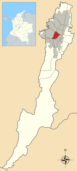
 Location of the locality in the city of Bogotá |
|
 Location of the locality in the Capital District of Bogotá |
|
| Coordinates: 4°36′45″N 74°06′24″W / 4.61250°N 74.10667°WCoordinates: 4°36′45″N 74°06′24″W / 4.61250°N 74.10667°W | |
| Country |
|
| City | Bogotá D.C. |
| Area | |
| • Total | 17.31 km2 (6.68 sq mi) |
| Elevation | 2,600 m (8,500 ft) |
| Population (2007) | |
| • Total | 250,715 |
| • Density | 14,000/km2 (38,000/sq mi) |
| Time zone | Colombia Standard Time (UTC-5) |
| Website | Official website |
Puente Aranda is the 16th location of the Capital District of the Colombian capital city, Bogotá. It is located in the central-western part of Bogotá and was named after an old bridge in the hacienda of Juan Aranda over the "Chinúa River", now called the San Francisco River, that dates to the 16th century. Puente Aranda has 1,724 hectares (4,260 acres) of area which are almost entirely urban. This locality has more than 300,000 inhabitants, 5% of the total urban area inhabitants of Bogota.
To the north, the locality of Puente Aranda borders Calle 19, which serves as boundary with the locality of Teusaquillo. To the south Puente Aranda borders the Autopista Sur and the localities of Tunjuelito and Antonio Nariño, to the east with the main avenue Norte-Quito-Sur and the locality of Los Mártires. To the west, Puente Aranda borders the Avenida Carrera 68 and the localities of Kennedy and Fontibón.
Puente Aranda was in the past a convergence of many streams and wetlands on the Bogotá savanna. It suffered frequent floodings, in contrast with the now almost entirely urbanized flat area with a slight increase in elevation from east to west.
The Fucha River, the San Cristobal River and the "Canal de los Comuneros" crosses the locality among other canalized streams like Seco River, La Albania River, and the San Francisco River.
The Puente Aranda hacienda was property of Don Jorge Aranda, and was established in a marshy terrain south of the then village of Santafé in the 16th century by the oidor Francisco de Anuncibay who arrived to the New Kingdom of Granada in the year 1537. This hacienda was first named "Hacienda of Aranda" and "The Roof of the Jorges", where the rivers Chinúa and San Agustín merged. It was also the main western path to get to the Magdalena River, which was and still is the most important fluvial artery of Colombia and a bridge was built to facilitate this. Floodings of the Bogotá River and its tributaries was frequent. In 1768, a bridge was reconstructed with a better structure and named Puente de Aranda (Aranda's Bridge). Then, an esplanade was built along across the wetlands, towards the west in an effort to connect Bogotá with the port of Honda along the Magdalena River. This way, Honda was then connected to Fontibón and the "Avenida de Encomienda", nowadays Calle 13 (Avenida del Centenario). Simón Bolívar and his troops camped in the Hacienda of Aranda in 1814 during the wars of independence from Spain.
...
Wikipedia
