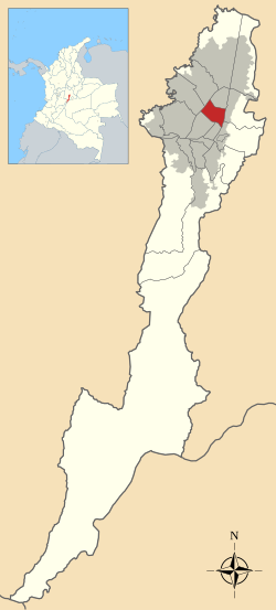
Teusaquillo
| Teusaquillo | |
|---|---|
| Locality of Bogotá | |
 Location of the locality in the city of Bogotá |
|
 Location of the locality in the Capital District of Bogotá |
|
| Coordinates: 4°40′14″N 74°05′35″W / 4.67056°N 74.09306°WCoordinates: 4°40′14″N 74°05′35″W / 4.67056°N 74.09306°W | |
| Country |
|
| City | Bogotá D.C. |
| Neighbourhoods | |
| Area | |
| • Total | 14.19 km2 (5.48 sq mi) |
| Elevation | 2,600 m (8,500 ft) |
| Population (2007) | |
| • Total | 139,298 |
| • Density | 9,800/km2 (25,000/sq mi) |
| Time zone | Colombia Standard Time (UTC-5) |
| Website | Official website |
Teusaquillo is the 13th locality of Bogotá, capital of Colombia. It is located in the geographic center of the city, to the northwest of downtown Bogotá. It is an urbanized locality with several green zones as parks, avenues, and the campus of the National University of Colombia. It is located on the former site of an indigenous resguardo known as Pueblo Viejo (Old Village), which existed until the main urbanization phase of the 20th century.
The total area of the locality is 14.19 square kilometres (5.48 sq mi), making the locality 11th of the 20 localities in terms of surface area.
The locality is located in the Salitre and Fucha River basins. The Simón Bolívar park also includes several lakes. Teusaquillo is crossed by various canals, which form part of the rainwater management system of Bogotá. They are extensions of streams that are sourced by the Eastern Hills.
Teusaquillo is relatively flat due to its location on the Bogotá savanna. It slopes slightly to the northwest.
The name Teusaquillo, like the name of Bogotá itself, dates to pre-Columbian times. Similar to the city, the name corresponded to a different location that is located near the present-day municipality of Funza. That, in turn, was known as Bacatá and was the main settlement of the southern Muisca Confederation. Within the zipazgo was Teivzaquillo, Thibzaquivo, Teusacá or Tipizaquillo, the place of rest of the zipa; the leader of the Muisca in Bacatá. Teusacá in Muysccubun means "borrowed enclosure".
Located in the foothills of the Eastern Ranges of the Colombian Andes, the Bogotá savanna was discovered by conquistador Gonzalo Jiménez de Quesada. It was conquered by the Spanish who founded the town of Santafé de Bogotá on August 6, 1538, located in present-day La Candelaria. as the capital of the New Kingdom of Granada. At that time, the name Teivzaquillo fell out of use.
...
Wikipedia
