Pucaranra
| Pucaranra | |
|---|---|

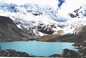
Palcaraju (on the left) and Pucaranra (on the right) behind Lake Palcacocha
|
|
| Highest point | |
| Elevation | 6,147 m (20,167 ft) |
| Coordinates | 9°23′30″S 77°21′03″W / 9.39167°S 77.35083°WCoordinates: 9°23′30″S 77°21′03″W / 9.39167°S 77.35083°W |
| Geography | |
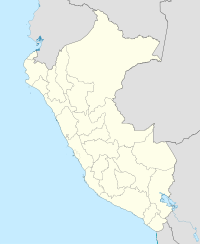
| Location | Peru, Ancash Region |
| Parent range | Andes, Cordillera Blanca |
| Climbing | |
| First ascent |
1948 via S.W. spur of S. ridge?: Variant on S.W. side-1954: E. slopes-1957: N.E. ridge-1959: S.W. ridge, S.W. face-1965: W. ridge-1977 |
| Easiest route | southeast ridge, AD |
1948 via S.W. spur of S. ridge?: Variant on S.W. side-1954: E. slopes-1957:
Pucaranra (possibly from Quechua puka red, ranra stony; stony ground,) is a mountain in the Cordillera Blanca in the Andes of Peru, about 6,147 metres (20,167 ft) high (although other sources cite an elevation of 6,156 metres (20,197 ft). It is located in Ancash, southwest of mount Chinchey.
Several interesting lines on this mountain, none of them very serious but all requiring commitment. The east-northeast ridge is rated AD/D (depending on conditions), the southeast face AD+ and the southeast ridge AD.
...
Wikipedia

