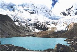
Lake Palcacocha
| Lake Palcacocha | |
|---|---|

2002
|
|
| Location | Ancash Region |
| Coordinates | 9°23′49″S 77°22′47″W / 9.39694°S 77.37972°WCoordinates: 9°23′49″S 77°22′47″W / 9.39694°S 77.37972°W |
| Basin countries | Peru |
| Surface elevation | 4,566 m (14,980 ft) |
Palcacocha (possibly from Quechua pallqa, p'allqa, p'alqa forked, branched, fork, qucha lake) is a glacier lake in the Andes mountain range of South America in northwestern Peru located in the Ancash Region, Huaraz Province.
Palcacocha is located at 9°23′49″S 77°22′47″W / 9.39694°S 77.37972°W in the Ancash Region in Cordillera Blanca at an elevation of 4,566 m, just below the summits of Palcaraju (6,274 m) and Pucaranra (6,156 m). The lake is one of several lakes supplying the town Huaraz with water, 23 km to the southwest.
On the early morning of 13 December 1941 a huge chunk of the adjacent glacier fell into Lake Palcacocha causing the breaking of the moraine walls that limit the lake downhill. The wave hurtled down the Cojup valley, destroying Lake Jiracocha on its way and carrying blocks of ice, large rock boulders and liquid mud towards the Santa River valley. Within 15 minutes the mudslide reached Huaraz, with 400 m³ of debris burying parts of the town and killing approximately 6,000 to 7,000 inhabitants.
In April 2003, NASA scientists discovered a fissure in the glacier above Lake Palcacocha on Terra satellite images of November 2001. Their warnings reached Peru just two weeks after the staff of the UGRH (Unidad de Glaciologia y Recursos Hidricos) had done some field mapping of Lake Palcacocha, where a moraine rupture had caused a minor flood on 19 March 2003 which the safety constructions from the 1940s had captured.
...
Wikipedia
