Prvić (Krk)

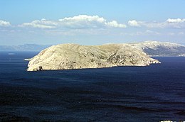
View of Prvić from Velebit
|
|
| Geography | |
|---|---|
| Location | Adriatic Sea |
| Coordinates | 44°54′38″N 14°48′05″E / 44.91056°N 14.80139°ECoordinates: 44°54′38″N 14°48′05″E / 44.91056°N 14.80139°E |
| Archipelago | Kvarner Gulf, Senj Islands |
| Area | 12.76 km2 (4.93 sq mi) |
| Length | 7.4 km (4.6 mi) |
| Coastline | 23.12 km (14.366 mi) |
| Highest elevation | 357 m (1,171 ft) |
| Highest point | Šipovac |
| Administration | |
| County | Primorje-Gorski Kotar |
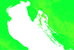
Prvić (pronounced [pr̩̂v̞itɕ], or Parvić in the Chakavian dialect; Pervicchio in Italian) is an uninhabited island in the Croatian part of the Adriatic Sea, located in the Kvarner Gulf. It is the largest of the so-called Senj Islands, a group of small islands and islets located off the coast of the mainland city of Senj, lying between the larger islands of Krk and Rab. Other significant islands in the Senj group are Sveti Grgur and Goli otok, along with a number of islets and rocks, which are all uninhabited. Prvić has an area is 12.76 square kilometres (4.93 sq mi), which makes it the 30th largest Croatian island, and its coastline is 23.12 kilometres (14.37 miles) long.
Prvić is located southeast of Krk, separated from it by an 800 m wide Senj Passage (Senjska vrata) and it is geomorphologically considered part of the same landform as the Obzova hill, Krk's highest peak (578 meters above sea level), which forms the southwestern part of the Baška cove with the coastal town of Baška. Prvić's southernmost cape Šilo is 4 km (2 mi) away from the mainland as the crow flies and it is the point closest to mainland. Harbours nearest to Prvić are Sveti Juraj, a hamlet near Senj at the foot of the Velebit, and Baška on the island of Krk. The island itself is shaped like a steep cliff stretching northwest-southeast and is 7.4 km (4.6 mi) long. Its westernmost point is called Debeli Art and its northernmost point is cape Brezonjin, where the automatic Stražica Lighthouse is located.
Three km (1.9 miles) southwest of Prvić is the island of Sveti Grgur (or Saint Gregory, also known as Šagargur, its name in the Chakavian dialect), separated from Prvić by the Grgurov kanal (Eng: Gregory's Channel). In addition, three kilometres to the south of Prvić's southernmost point, cape Šilo, is Goli otok (lit. Barren Island). Like Prvić, both Sveti Grgur and Goli otok are today uninhabited, but they have become infamous as places where political prisoners were often sent in the Informbiro period between 1949 and 1956. They were used as prisons up until the late 1980s when they were shut down and abandoned.
...
Wikipedia

