Velebit
| Velebit | |
|---|---|

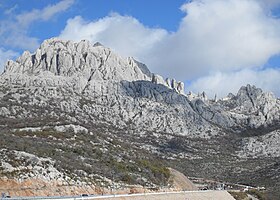
The Sveti Rok Tunnel passes underneath Velebit.
|
|
| Highest point | |
| Elevation | 1,757 m (5,764 ft) |
| Coordinates | 44°32′N 15°14′E / 44.533°N 15.233°ECoordinates: 44°32′N 15°14′E / 44.533°N 15.233°E |
| Geography | |
| Location | Croatia |
| Parent range | Dinaric Alps |
Velebit (pronounced [v̞ɛlɛ̌bit]; Italian: Alpi Bebie) is the largest though not the highest mountain range in Croatia. Its highest peak is the Vaganski vrh at 1,757 m.
The range forms a part of the Dinaric Alps and is located along the Adriatic coast, separating it from Lika in the interior. Velebit begins in the northwest near Senj with the Vratnik mountain pass and ends 145 km to the southeast near the source of the Zrmanja river northwest of Knin.
Major mountain passes on Velebit include the aforementioned Vratnik or Senjsko bilo at 694 m.a.s.l., where the Josephina connects Senj with Josipdol; Oštarijska vrata at 928 m.a.s.l. that connects Karlobag and Gospić; and Prezid at 766 m.a.s.l. that connects Obrovac and Gračac.
The important characteristic of Velebit are its simple, solid form, stiff cliffs, and the nakedness of seaward side and the wood-covered slopes of the Lika side. The basic geological characteristic of the mountains is karst; flora and fauna are abundant. The most popular spots on Velebit are: the peak of Vučjak, above Zavižan, the botanical gardens on Zavižan, Rožanski kukovi, Štirovača and the Paklenica National Park.
The Croatian Meteorological and Hydrological Service has a permanent measurement station at Zavižan.
...
Wikipedia

