Knin
| Knin | ||
|---|---|---|
| City | ||

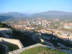
View over Knin
|
||
|
||
| Location of Knin within Croatia | ||
| Coordinates: 44°02′2″N 16°11′33″E / 44.03389°N 16.19250°ECoordinates: 44°02′2″N 16°11′33″E / 44.03389°N 16.19250°E | ||
| Country |
|
|
| County |
|
|
| Government | ||
| • Type | Mayor-Council | |
| • Mayor | Nikola Blažević (HDZ) | |
| • City Council |
17 members
|
|
| Area | ||
| • Total | 355 km2 (137 sq mi) | |
| Elevation | 214 m (702 ft) | |
| Population (2011) | ||
| • Total | 10,633 | |
| • Administrative area | 15,407 | |
| Time zone | CET (UTC+1) | |
| • Summer (DST) | CEST (UTC+2) | |
| Postal code | 22300 | |
| Area code(s) | 022 | |
| Climate | Cfa | |
| Website | www |
|
Knin (pronounced [knîːn]) is a city in the Šibenik-Knin County of Croatia, located in the Dalmatian hinterland near the source of the river Krka, an important traffic junction on the rail and road routes between Zagreb and Split. Knin rose to prominence twice in history, as the capital of both the medieval Kingdom of Croatia and, briefly, of the self-proclaimed Republic of Serbian Krajina at the end of the 20th century.
The name is likely derived from the Illyrian Ninia. According to an alternative explanation, offered by Franc Miklošič and Petar Skok, the name - derived from a Slavic root *tьn- ("to cut", "to chop") - has a meaning of "cleared forest". The medieval names of Knin include Hungarian: Tinin; Italian: Tenin; Latin: Tinum. The Latin name is still used as a titular episcopal see, the Diocese of Tinum.
The area consisting of today's Knin, or more specifically, the Spas hill, was inhabited since the stone age. In the vicinity of today's Knin was once a town called Burnum, which served as a Roman military camp in the 1st century BC.
A stone inscription from the 9th century found next to Knin castle attests the presence of Croatian duke Trpimir I, who may have founded a convent there.
...
Wikipedia


