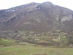
Pruno (Cilento)
| Pruno | |
|---|---|
| Frazione | |

View of Pruno di Laurino
|
|
| Location of Pruno in Italy | |
| Coordinates: 40°16′N 15°24′E / 40.267°N 15.400°ECoordinates: 40°16′N 15°24′E / 40.267°N 15.400°E | |
| Country |
|
| Region |
|
| Province |
|
| Comune |
|
| Elevation | 1,100 m (3,600 ft) |
| Population | |
| • Total | 40 |
| Demonym(s) | Prunesi |
| Time zone | CET (UTC+1) |
| • Summer (DST) | CEST (UTC+2) |
| Postal code | 84057 (Laurino) 84070 (Valle dell'Angelo) 84065 (Piaggine) |
| Dialing code | (+39) 0974 |
Pruno is a forest in the Campania region of southern Italy. It is the largest woodlands of central Cilento region. The hamlets (frazioni) with this name are situated in the municipalities of Laurino, Valle dell'Angelo and Piaggine, and are considered a singular village.
Pruno represents one of the most unpolluted natural areas of Campania and one of the lesser inhabited territories of Southern Italy. It is protected within the Cilento and Vallo di Diano National Park, and is part of the Cilento World Heritage Site.
The area of Pruno has been inhabited for centuries by farmers. It had two periods of emigration during the end of 19th century and the second half of 20th.
Pruno is situated in south of the Province of Salerno, in the Cilento and Vallo di Diano National Park. The forest is located between Mount Gelbison and Mount Cervati mounts, at elevations between 600–1,300 metres (2,000–4,300 ft) above mean sea level.
The area is extended not only in the comunes of Valle dell'Angelo, Laurino and Piaggine; but also in Cannalonga, Campora, Rofrano, Sanza, Novi Velia and Monte San Giacomo; and is surrounded by other forest areas. The mountains of the areas are Vesalo, Monaco, Faiatella, Scanno del Tesoro, Raia del Pedale, and Tuzzi di Monte Piano. There are also the springs of Calore River, and some caves with prehistoric rock art.
...
Wikipedia

