Provideniya
| Provideniya (English) Провидения (Russian) Гуврэл (Chukchi) |
|
|---|---|
| - Urban-type settlement - | |
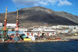
 View of Provideniya from Komsomolskaya Bay |
|
 Location of Chukotka Autonomous Okrug in Russia |
|
|
|
|
|
|
|
| Administrative status (as of June 2012) | |
| Country | Russia |
| Federal subject | Chukotka Autonomous Okrug |
| Administrative district | Providensky District |
| Administrative center of | Providensky District |
| Municipal status (as of October 2010) | |
| Municipal district | Providensky Municipal District |
| Urban settlement | Provideniya Urban Settlement |
| Administrative center of | Providensky Municipal District, Provideniya Urban Settlement |
| Head | Dmitry Olkhovik |
| Statistics | |
| Population (2010 Census) | 1,970 inhabitants |
| Population (January 2016 est.) | 2,082 inhabitants |
| Time zone | PETT (UTC+12:00) |
| Founded | May 10, 1946 |
| Urban-type settlement status since | April 25, 1957 |
| Postal code(s) | 689251 |
| on | |
Provideniya (Russian: Провиде́ния, lit. of providence; Chukchi: Гуврэл) is an urban locality (an urban-type settlement) and the administrative center of Providensky District of Chukotka Autonomous Okrug, Russia, located on Komsomolskaya Bay (a part of Provideniya Bay) in the northeastern part of the autonomous okrug, across the Bering Strait from Alaska, and very close to the International Date Line. Population: 1,970 (2010 Census);2,723 (2002 Census);5,432 (1989 Census).
Provideniya is a former Soviet military port, sited on a fjord sheltered from the Bering Sea. The largest inhabited locality east of Anadyr, it was established as a port to serve the eastern end of the Northern Sea Route. The port is found in Komsomolskaya Bay (named after the Soviet Komsomol youth organization), a part of the much larger Provideniya Bay, providing a suitable deep water harbor for Russian ships, close to the southern limits of the winter ice fields.
After discovery in 1660 of Providence Bay by the Russian expedition led by Kurbata Ivanov, the surrounding waters became a regular site for wintering fishing, whaling, and merchant ships. In the early 20th century, with the beginning of the development of the Northern Sea Route along the coast of the bay, a coal depot was constructed for refueling ships heading west back across the Arctic and in 1933 the first buildings of the future seaport were constructed in what would later become the settlement of Provideniya. In 1937, with the arrival of a convoy with building materials for the construction company Providenstroy, active construction of the port and the settlement began. On May 10, 1946, the settlement of Provideniya was officially established by the Decree of the Presidium of the Supreme Soviet of the Russian SFSR. The settlement continued to grow quickly and military units began to be deployed here. On April 25, 1957, it was granted work settlement status. In 1975, it was planned to grow the settlement into a town with a population of twelve thousand and to rename it "Dezhnyov". However, social and economic upheavals in the post-Soviet period left these plans unfulfilled and in the period from 1994 to 2002 no construction was undertaken at all.
...
Wikipedia

