Princeton, Massachusetts
| Princeton, Massachusetts | |||
|---|---|---|---|
| Town | |||

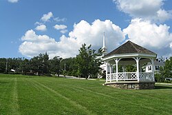
Town Common in Princeton, MA
|
|||
|
|||
 Location in Worcester County and the state of Massachusetts. |
|||
| Coordinates: 42°26′55″N 71°52′40″W / 42.44861°N 71.87778°WCoordinates: 42°26′55″N 71°52′40″W / 42.44861°N 71.87778°W | |||
| Country | United States | ||
| State | Massachusetts | ||
| County | Worcester | ||
| Settled | 1743 | ||
| Incorporated | 1771 | ||
| Government | |||
| • Type | Open town meeting | ||
| • Town Administrator |
Nina Nazarian | ||
| • Board of Selectmen |
Edith M. Morgan, Chairman Stan Moss Neil A. Sulmasy |
||
| Area | |||
| • Total | 35.8 sq mi (92.8 km2) | ||
| • Land | 35.4 sq mi (91.8 km2) | ||
| • Water | 0.4 sq mi (1.0 km2) | ||
| Elevation | 1,175 ft (358 m) | ||
| Population (2010) | |||
| • Total | 3,413 | ||
| • Density | 94.6/sq mi (36.5/km2) | ||
| Time zone | Eastern (UTC-5) | ||
| • Summer (DST) | Eastern (UTC-4) | ||
| ZIP code | 01541 | ||
| Area code(s) | 351 / 978 | ||
| FIPS code | 25-55395 | ||
| GNIS feature ID | 0618380 | ||
| Website | http://town.princeton.ma.us/ | ||
Princeton is a town in Worcester County, Massachusetts, United States. It is bordered on the east by Sterling and Leominster, on the north by Westminster, on the northwest by Hubbardston, on the southwest by Rutland, and on the southeast by Holden. The preeminent landmark within Princeton is Mount Wachusett, which straddles the line between Princeton and Westminster but the entrance to which is within Princeton. According to tradition, in 1675, Mary Rowlandson was ransomed upon Redemption Rock, now within the town of Princeton, by King Philip. The population was 3,413 at the 2010 census.
Princeton was created in 1759, out of land that was once part of Rutland. It was named after the Rev. Thomas Prince. In 1810, it annexed a piece of Hubbardston, and in 1870, it annexed a piece of Westminster.
Princeton has five entries on the National Register of Historic Places:
According to the United States Census Bureau, the town has a total area of 35.8 square miles (93 km2), of which, 35.4 square miles (92 km2) of it is land and 0.4 square miles (1.0 km2) of it (1.12%) is water.
As of the census of 2000, there were 3,353 people, 1,166 households, and 959 families residing in the town. The population density was 94.6 inhabitants per square mile (36.5/km2). There were 1,196 housing units at an average density of 33.7 per square mile (13.0/km2). The racial makeup of the town was 96.75% White, 0.30% African American, 0.33% Native American, 0.95% Asian, 0.63% from other races, and 1.04% from two or more races. Hispanic or Latino of any race were 1.46% of the population.
...
Wikipedia


