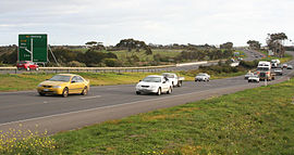
Princes Freeway
|
Princes Freeway Victoria |
|
|---|---|
 |
|
| Princes Freeway at Lara | |
| Type | Freeway |
| Length | 159 km (99 mi) |
| Route number(s) |
|
| Former route number |
|
| West end | |
| East end | |
| Major suburbs / towns | Geelong, Little River, Werribee, Warragul, Trafalgar, Moe, Morwell, Traralgon |
|
Highways in Australia National Highway • Freeways in Australia Highways in Victoria |
|
The Princes Freeway is a 159-kilometre (99 mi) Australian freeway, divided into two sections both located in Victoria. The freeway links Melbourne to Geelong on the west (47 kilometres (29 mi)) and Traralgon on the east (112 kilometres (70 mi)). It continues beyond these extremities as the Princes Highway towards Adelaide to the west and Sydney to the northeast. The freeway bears the designation M1.
The western section linking Geelong and Melbourne is an important commuter and freight route between the two cities; the eastern section links Melbourne with the Latrobe Valley. The entire freeway is one of the busiest sections of rural highway in Victoria, used by large numbers of freight and commercial vehicles and provides access to tourist attractions in central and east Gippsland. It supports Victoria's rural industries and tourism.
The western section (also known as Princes Freeway West or Geelong Road) starts from Altona at the West Gate Interchange, where the Western Ring Road and the old Geelong Road can be accessed by off ramps, and ends at Geelong. This section ranges from six lanes (three in each direction) between Geelong and Werribee, to ten lanes near the Ring Road interchange. Between 1999 and 2003 the section from Hoppers Crossing to Geelong was progressively widened to provide a third lane in each direction, in addition to a number of other safety upgrades being completed. Following this upgrade the speed limit was lowered from 110 kilometres per hour (68 mph) to 100 kilometres per hour (62 mph) in response to the freeway's poor safety record.
The eastern section (also known as Princes Freeway East) starts from Berwick, a four lane (two lanes in each direction) divided freeway. There are also several highway standard at-grade intersections, most notably between Nar Nar Goon and Longwarry. These intersections are speed limited to 100 kilometres per hour (62 mph), with the only 110 kilometres per hour (68 mph) section on the freeway from Longwarry to Morwell. However, traffic still travel through the towns of Yarragon and Trafalgar, therefore urban speed limits apply to these towns (between 60 and 80 kilometres per hour (37 and 50 mph)) where the road reverts to the Princes Highway (though planning for bypasses of these towns are underway).
...
Wikipedia
