Morwell, Victoria
|
Morwell Victoria |
|||||||||||||
|---|---|---|---|---|---|---|---|---|---|---|---|---|---|

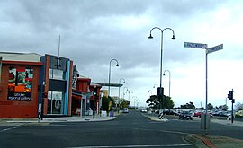
Corner of Hazelwood and Commercial Roads, Morwell
|
|||||||||||||
| Coordinates | 38°14′S 146°24′E / 38.233°S 146.400°ECoordinates: 38°14′S 146°24′E / 38.233°S 146.400°E | ||||||||||||
| Population | 13,691 (2011 census) | ||||||||||||
| Established | 1870s | ||||||||||||
| Postcode(s) | 3840 | ||||||||||||
| Elevation | 80 m (262 ft) | ||||||||||||
| Location | 149 km (93 mi) from Melbourne | ||||||||||||
| LGA(s) | City of Latrobe | ||||||||||||
| State electorate(s) | Morwell | ||||||||||||
| Federal Division(s) | Gippsland | ||||||||||||
|
|||||||||||||
Morwell is a town in the Latrobe Valley area of Gippsland, in South-Eastern Victoria, Australia approximately 149 km (93 mi) east of Melbourne. The population at the 2011 Census was 13,691.
It is both the seat of local government and administrative centre for the City of Latrobe. Morwell is central to the Latrobe Valley urban area which has a population of approximately 125,000 and as such has become home to many of the greater urban area's civic institutions, administrative functions and infrastructure.
The city is known for its role as a major energy production centre for Victoria as the centre of a major coal mining and fossil-fuel power generation industry.
The earliest inhabitants of the Morwell district were the Gunai (sometimes spelled Kurnai) Indigenous Australians. Their first contact with Europeans would have been with pastoralists who came south from the Monaro region of New South Wales in the 1840s in search of pasture for their stock.
In 1841, McMillan and Strzelecki made journeys of exploration through the region which would later be named Gippsland and during the 1840s the squatting runs of Maryvale, Merton Rush and Hazelwood were taken up in the area which is now Morwell.
The name of the Morwell River is allegedly the anglicised form of the Aboriginal words more willie meaning woolly possum. In turn, this became the name for the public house by the river and the early settlement nearby.
...
Wikipedia

