Preston-Potter Hollow, New York
| Preston-Potter Hollow, New York | |
|---|---|
| Census-designated place | |

Church in Preston-Potter Hollow
|
|
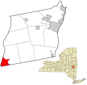
 Location in Albany County and the state of New York. |
|
| Coordinates: 42°25′53″N 74°13′23″W / 42.43139°N 74.22306°WCoordinates: 42°25′53″N 74°13′23″W / 42.43139°N 74.22306°W | |
| Country | United States |
| State | New York |
| County | Albany |
| Town | Rensselaerville |
| Area | |
| • Total | 10.1 sq mi (26.2 km2) |
| • Land | 10.1 sq mi (26.2 km2) |
| • Water | 0.0 sq mi (0.0 km2) |
| Population (2010) | |
| • Total | 366 |
| • Density | 36/sq mi (13.9/km2) |
| Time zone | Eastern (EST) (UTC-5) |
| • Summer (DST) | EDT (UTC-4) |
| FIPS code | 36-59831 |
Preston-Potter Hollow is a census-designated place (CDP) in Albany County, New York, United States. The population was 366 at the 2010 census.
Preston and Potter Hollow are two hamlets in the town of Rensselaerville, located in the southwest corner of Albany County. The communities are near the border of Greene County, New York.
The Potter Hollow District No. 19 School and Sidney White House are listed on the National Register of Historic Places.
Preston-Potter Hollow is located at 42°25′53″N 74°13′23″W / 42.43139°N 74.22306°W (42.431357, -74.223113).
According to the United States Census Bureau, the CDP has a total area of 10.1 square miles (26 km2), all land.
It is also the topographical location of Potter Hollow.
As of the census of 2000, there were 374 people, 152 households, and 103 families residing in the CDP. The population density was 37.0 per square mile (14.3/km²). There were 235 housing units at an average density of 23.2/sq mi (9.0/km²). The racial makeup of the CDP was 94.65% White, 3.48% African American, 0.27% Asian, and 1.60% from two or more races. Hispanic or Latino of any race were 0.27% of the population.
...
Wikipedia
