Preston, Minnesota
| Preston, Minnesota | |
|---|---|
| City | |

Preston Main Street commercial district
|
|
| Nickname(s): "America's Trout Capital" | |
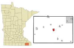
 Location of Preston within Fillmore County and state of Minnesota |
|
| Coordinates: 43°40′21″N 92°4′58″W / 43.67250°N 92.08278°W | |
| Country | United States |
| State | Minnesota |
| County | Fillmore |
| Area | |
| • Total | 2.45 sq mi (6.35 km2) |
| • Land | 2.45 sq mi (6.35 km2) |
| • Water | 0 sq mi (0 km2) |
| Elevation | 958 ft (292 m) |
| Population (2010) | |
| • Total | 1,325 |
| • Estimate (2012) | 1,312 |
| • Density | 540.8/sq mi (208.8/km2) |
| Time zone | Central (CST) (UTC-6) |
| • Summer (DST) | CDT (UTC-5) |
| ZIP code | 55965 |
| Area code(s) | 507 |
| FIPS code | 27-52450 |
| GNIS feature ID | 0649730 |
Preston is a city in Fillmore County, Minnesota, United States. The population was 1,325 at the 2010 census. It is the county seat of Fillmore County. The Root River runs through it, and Mystery Cave State Park is nearby. It bills itself as "America's Trout Capital," with a 20-foot trout placed along Minnesota State Highway 16.
Preston was platted in 1855. The community was named for Luther Preston, a millwright and postmaster. The old Preston grain elevator used to be known as the Milwaukee Elevator Company Grain Elevator. It was built around 1890 for holding grain for shipment by railroad to the Eastern cities of the United States. The elevator was last used in the 1980s. It was built with "cribbed" construction, which has to do with interlocking bins. At the time it was a lot stronger and a lot more expensive to build it this way than to build it in stud construction. Now the Preston Historical Society is trying to restore the structure.
The Preston Overlook was built in 1937 by the Minnesota Department of Highways under the program of Federal Relief Construction during the New Deal. A site was chosen on the highest point on the bluffs above the Root River, 90 feet below. The Preston Overlook was listed on the National Register of Historic Places in 2003.
...
Wikipedia
