Prairie County, Arkansas
| Prairie County, Arkansas | |
|---|---|
| County | |
| County of Prairie | |

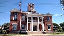
Prairie County Courthouse, Des Arc
|
|
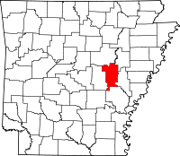
 Location in the U.S. state of Arkansas |
|
 Arkansas's location in the U.S. |
|
| Founded | November 25, 1846 |
| Named for | Grand Prairie |
| Seat | Des Arc, De Valls Bluff |
| Largest city | Des Arc |
| Area | |
| • Total | 676 sq mi (1,751 km2) |
| • Land | 648 sq mi (1,678 km2) |
| • Water | 28 sq mi (73 km2), 4.1% |
| Population (est.) | |
| • (2015) | 8,291 |
| • Density | 13/sq mi (5/km²) |
| Congressional district | 1st |
| Time zone | Central: UTC-6/-5 |
Prairie County is located in the Central Arkansas region of the U.S. state of Arkansas. The county is named for the Grand Prairie, a subregion of the Arkansas Delta known for rice cultivation and aquaculture which runs through the county. Created as Arkansas's 54th county in 1864, Prairie County is home to four incorporated towns, including DeValls Bluff, the southern district county seat, and two incorporated cities, including Des Arc, the northern district county seat. The county is also the site of numerous unincorporated communities and ghost towns. Occupying 676 square miles (175,000 ha), Prairie County is the median-sized county in Arkansas. As of the 2010 Census, the county's population is 8,715 people in 4,503 households. Based on population, the county is the ninth-smallest county of the 75 in Arkansas.
The county is crossed by Interstate 40 (I-40), a major east-west Interstate highway running from California to North Carolina, as well as four United States highways (U.S. Route 63 [US 63], US 70, US 79, and US 165). Eleven Arkansas state highways run in the county. Prairie County is served by two public owned/public use general aviation airports and six potable water systems.
...
Wikipedia
