Des Arc, Arkansas
| Des Arc, Arkansas | |
|---|---|
| City | |

Clockwise, from top: Downtown Des Arc, the Lower White River State Park, the White River bridge, Prairie County Courthouse, Northern District
|
|
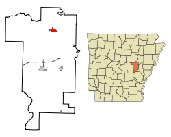
 Location in Prairie County and the state of Arkansas |
|
| Coordinates: 34°58′32″N 91°30′2″W / 34.97556°N 91.50056°WCoordinates: 34°58′32″N 91°30′2″W / 34.97556°N 91.50056°W | |
| Country | United States |
| State | Arkansas |
| County | Prairie |
| Area | |
| • Total | 2 sq mi (5.3 km2) |
| • Land | 2 sq mi (5.3 km2) |
| • Water | 0 sq mi (0 km2) |
| Elevation | 200 ft (61 m) |
| Population (2000) | |
| • Total | 1,933 |
| • Density | 966.5/sq mi (364.7/km2) |
| Time zone | Central (CST) (UTC-6) |
| • Summer (DST) | CDT (UTC-5) |
| ZIP code | 72040 |
| Area code(s) | 870 |
| FIPS code | 05-18550 |
| GNIS feature ID | 0076785 |
Des Arc is a city in and the county seat of the northern district of Prairie County, Arkansas, United States. The population was 1,933 at the 2000 census.
Des Arc is located at 34°58′32″N 91°30′2″W / 34.97556°N 91.50056°W (34.975426, -91.500671).
According to the United States Census Bureau, the city has a total area of 2.0 square miles (5.2 km2), of which 2.0 square miles (5.2 km2) is land and 0.49% is water.
Prairie County has a humid subtropical climate (Köppen Cfa). Prairie County experiences all four seasons, although summers can be extremely hot and humid and winters are mild with little snow. July is the hottest month of the year, with an average high of 92 °F (33.3 °C) and an average low of 73 °F (22.8 °C). Temperatures above 100 °F (38 °C) are not uncommon. January is the coldest month with an average high of 48 °F (8.9 °C) and an average low of 31 °F (−0.6 °C). The highest temperature was 109 °F (42.8 °C), and the lowest temperature recorded was −5 °F (−21 °C). Record snowfall in Des Arc occurred January 7, 1912, with 18 inches (46 cm).
Des Arc has seven properties listed on the National Register of Historic Places, including Bethel House, at Erwin and 2nd Streets, designed by architect Charles L. Thompson.
...
Wikipedia
