Port Orange, FL
| Port Orange, Florida | |||
|---|---|---|---|
| City | |||

Port Orange City Hall
|
|||
|
|||
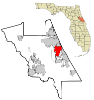
 Location in Volusia County and the state of Florida |
|||
 U.S. Census Bureau map showing city limits |
|||
| Coordinates: 29°7′8″N 81°0′10″W / 29.11889°N 81.00278°WCoordinates: 29°7′8″N 81°0′10″W / 29.11889°N 81.00278°W | |||
| Country |
|
||
| State |
|
||
| County | Volusia | ||
| Incorporated | 26 April 1867 | ||
| Government | |||
| • Type | Council-Manager | ||
| • Mayor | Donald O. Burnette, MBA | ||
| • City Manager | Michael H. "Jake" Johansson Michael Johansson, City Manager | ||
| Area | |||
| • City | 28.7 sq mi (74.3 km2) | ||
| • Land | 26.6 sq mi (69.0 km2) | ||
| • Water | 2.0 sq mi (5.3 km2) 7.1% | ||
| Elevation | 3 ft (0.9 m) | ||
| Population (2010) | |||
| • City | 56,048 | ||
| • Density | 2,000/sq mi (750/km2) | ||
| • Metro | 494,593 | ||
| Time zone | EST (UTC-5) | ||
| • Summer (DST) | EDT (UTC-4) | ||
| ZIP code | 32123, 32127-32129 | ||
| Area code(s) | 386 | ||
| FIPS code | 12-58575 | ||
| GNIS feature ID | 0295559 | ||
| Website | http://www.port-orange.org | ||
Port Orange is a city in Volusia County, Florida, United States. The city's estimated population was 57,203 in 2013. The city is part of the Deltona-Daytona Beach-Ormond Beach, Florida Metropolitan Statistical Area; the metropolitan area's population in 2010 was 590,289. Port Orange is a principal city in the Fun Coast region of the state of Florida.
Port Orange was settled by John Milton Hawks, who brought freed blacks to work at his sawmill after the U.S. Civil War. Esther Hawks established an integrated school in the area. The colony struggled soon after its creation and most colonists left. The area that became known as Freemanville is a legacy of the settlers who stayed in the area.
Port Orange is located at 29°7′8″N 81°0′10″W / 29.11889°N 81.00278°W (29.118970, -81.002906). According to the United States Census Bureau, the city has a total area of 28.7 square miles (74.3 km2), of which 26.6 square miles (69.0 km2) is land and 2.0 square miles (5.3 km2) (7.09%) is water.
As of the census of 2010, there were 56,048 people, 24,841 households, and 1,544 families residing in the city. The population density was 2,102.3 per square mile . There were 27,972 housing units at an average density of 1,049.2 per square mile (329.7/km²). The racial makeup of the city was 91.3% White, 3.3% African American, 0.3% Native American, 2.2% Asian, 0.02% Pacific Islander, 1.0% from other races, and 1.8% from two or more races. Hispanic or Latino of any race were 4.5% of the population.
...
Wikipedia


