Port Mansfield, TX
| Port Mansfield, Texas | |
|---|---|
| CDP | |
 |
|
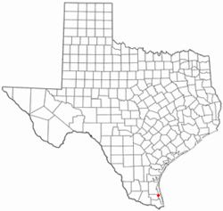
 Location of Port Mansfield, Texas |
|
 |
|
| Coordinates: 26°33′20″N 97°25′52″W / 26.55556°N 97.43111°WCoordinates: 26°33′20″N 97°25′52″W / 26.55556°N 97.43111°W | |
| Country | United States |
| State | Texas |
| County | Willacy |
| Area | |
| • Total | 5.7 sq mi (14.8 km2) |
| • Land | 5.2 sq mi (13.5 km2) |
| • Water | 0.5 sq mi (1.3 km2) |
| Elevation | 3 ft (1 m) |
| Population (2010) | |
| • Total | 226 |
| • Density | 40/sq mi (15/km2) |
| Time zone | Central (CST) (UTC-6) |
| • Summer (DST) | CDT (UTC-5) |
| ZIP code | 78598 |
| Area code(s) | 956 |
| FIPS code | 48-58928 |
| GNIS feature ID | 1344369 |
Port Mansfield is a census-designated place (CDP) in Willacy County, Texas, United States. The population was 226 at the 2010 census.
Port Mansfield is located at 26°33′20″N 97°25′52″W / 26.55556°N 97.43111°W (26.555453, -97.431051).
According to the United States Census Bureau, the CDP has a total area of 5.7 square miles (14.8 km²), of which, 5.2 square miles (13.5 km²) of it is land and 0.5 square miles (1.3 km²) of it (8.76%) is water. A navigational channel connects Port Mansfield to the Intracoastal Waterway, and to the Gulf of Mexico, cutting through Padre Island via the Port Mansfield Channel.
The cut through South Padre Island has shoaled considerably and as of early 2008, only shallow draft boats could safely enter at the Mansfield cut. The channel was dredged in the winter months of 2009-2010 by the United States Army Corps of Engineers using Federal relief money following Hurricanes Rita and Dolly. The channel is now 16–20 feet deep with all the dredge tailings making a beach on the north side of the jetty.
As of the census of 2000, there were 415 people, 187 households, and 137 families residing in the CDP. The population density was 79.6 people per square mile (30.8/km²). There were 563 housing units at an average density of 108.0 per square mile (41.7/km²). The racial makeup of the CDP was 93.01% White, 0.96% Native American, 4.58% from other races, and 1.45% from two or more races. Hispanic or Latino of any race were 14.22% of the population.
...
Wikipedia
