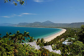
Port Douglas
|
Port Douglas Queensland |
|||||||
|---|---|---|---|---|---|---|---|

Four Mile Beach
|
|||||||
| Coordinates | 16°29′01″S 145°27′55″E / 16.48361°S 145.46528°ECoordinates: 16°29′01″S 145°27′55″E / 16.48361°S 145.46528°E | ||||||
| Population | 3,205 (2011 census) | ||||||
| Established | 1877 | ||||||
| Postcode(s) | 4877 | ||||||
| Elevation | 4 m (13 ft) | ||||||
| Location | |||||||
| LGA(s) | Shire of Douglas | ||||||
| County | Solander | ||||||
| State electorate(s) | Cook | ||||||
| Federal Division(s) | Leichhardt | ||||||
|
|||||||
Port Douglas is a town in Far North Queensland, Australia, approximately 70 km (40 mi) north of Cairns. Its permanent population was 3,205 at the time of the 2011 census. The town's population can often double, however, with the influx of tourists during the peak tourism season May–September. The town is named in honour of former Premier of Queensland, John Douglas. Port Douglas developed quickly based on the mining industry. Other parts of the area were established with timber cutting occurring in the area surrounding the Daintree River and with settlement starting to occur on lots around the Mossman River by 1880.
Previous names for the town included Terrigal, Island Point, Port Owen and Salisbury. The town is situated adjacent to two World Heritage areas, the Great Barrier Reef and the Daintree Rainforest.
Port Douglas was No. 3 on Australian Traveller magazine's list of 100 Best Towns In Australia.
The town is within the Federal electorate of Leichhardt, and within the State electorate of Cook. At local level, It is within the local government area of Shire of Douglas (between 2008 and 2013, it was within the Cairns Region).
The Port Douglas township was established in 1877 after the discovery of gold at Hodgkinson River by James Venture Mulligan. Port Douglas Post Office opened on 1 September 1877. It grew quickly, and at its peak Port Douglas had a population of 12,000 and 27 hotels. With the construction of the Mulligan Highway it serviced towns as far away as Herberton.
...
Wikipedia

