Porcupine, South Dakota
|
Porcupine, South Dakota pȟahíŋ siŋté |
|
|---|---|
| CDP | |
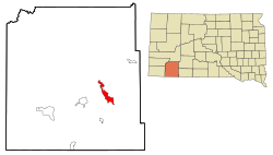
 Location in Oglala Lakota County and the state of South Dakota |
|
| Coordinates: 43°15′45″N 102°20′52″W / 43.26250°N 102.34778°WCoordinates: 43°15′45″N 102°20′52″W / 43.26250°N 102.34778°W | |
| Country | United States |
| State | South Dakota |
| County | Oglala Lakota |
| Area | |
| • Total | 9.5 sq mi (24.6 km2) |
| • Land | 9.5 sq mi (24.6 km2) |
| • Water | 0 sq mi (0 km2) |
| Elevation | 3,192 ft (973 m) |
| Population (2010) | |
| • Total | 1,062 |
| • Density | 111.8/sq mi (43.1/km2) |
| Time zone | Mountain (MST) (UTC-7) |
| • Summer (DST) | MDT (UTC-6) |
| ZIP code | 57772 |
| Area code(s) | 605 |
| FIPS code | 46-51340 |
| GNIS feature ID | 1257179 |
Porcupine (Lakota: pȟahíŋ siŋté; "porcupine tail") is a census-designated place (CDP) in Oglala Lakota County, South Dakota, United States. The population was 1,062 at the 2010 census.
The community most likely was named after Porcupine Butte. Porcupine has been noted for its unusual place name, and for its designation as the unofficial capital of the unrecognized Republic of Lakotah.
Porcupine is located at 43°15′45″N 102°20′52″W / 43.26250°N 102.34778°W (43.262380, -102.347660).
According to the United States Census Bureau, the CDP has a total area of 9.5 square miles (24.6 km²), all land.
Porcupine has been assigned the ZIP code 57772.
Porcupine is also the unofficial capital of the unrecognized Republic of Lakotah.
Porcupine is home to KILI (90.1 FM), a non-profit radio station broadcasting to the Lakota people on the Pine Ridge, Cheyenne River, and Rosebud Indian Reservations, part of the Great Sioux Nation. The station started broadcasting in 1983 as the first American Indian-owned radio station in the United States.
...
Wikipedia
