Pomfret, New York
| Pomfret, New York | |
|---|---|
| Town | |
 Location in Chautauqua County and New York |
|
| Location within the state of New York | |
| Coordinates: 42°25′2″N 79°21′2″W / 42.41722°N 79.35056°WCoordinates: 42°25′2″N 79°21′2″W / 42.41722°N 79.35056°W | |
| Country | United States |
| State | New York |
| County | Chautauqua |
| Government | |
| • Type | Town Council |
| • Town Supervisor | Donald R. Steger (D) |
| • Town Council |
Members' List
|
| Area | |
| • Total | 44.19 sq mi (114.45 km2) |
| • Land | 43.85 sq mi (113.58 km2) |
| • Water | 0.33 sq mi (0.87 km2) |
| Elevation | 994 ft (303 m) |
| Population (2010) | |
| • Total | 14,965 |
| • Estimate (2016) | 14,244 |
| • Density | 324.80/sq mi (125.41/km2) |
| Time zone | Eastern (EST) (UTC-5) |
| • Summer (DST) | EDT (UTC-4) |
| ZIP code | 14063 (Fredonia) |
| FIPS code | 36-013-58981 |
| GNIS feature ID | 0979382 |
| Website | townofpomfretny |
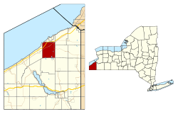
Pomfret is a town in Chautauqua County, New York, United States. The population was 14,965 at the 2010 census. The town lies in the north-central part of the county, south of Dunkirk, and includes the village of Fredonia.
The area was first settled around 1806. The town of Pomfret was formed in 1808 from the town of Chautauqua, being the first partition of Chautauqua after the county was formed. Pomfret later lost substantial parts of its territory during the formation of five new towns of the county.
According to the United States Census Bureau, Pomfret has a total area of 44.2 square miles (114.4 km2), of which 43.9 square miles (113.6 km2) is land and 0.35 square miles (0.9 km2), or 0.76%, is water.
The northwestern corner of the town borders Lake Erie.
The New York State Thruway (Interstate 90) and US 20 pass through the town. NY 60 is a major north-south highway, and NY 5 runs along the shore of Lake Erie.
As of the census of 2000, there were 14,703 people, 5,105 households, and 2,971 families residing in the town. The population density was 334.9 people per square mile (129.3/km²). There were 5,558 housing units at an average density of 126.6 per square mile (48.9/km²). The racial makeup of the town was 95.28% White, 2.07% African American, 0.33% Native American, 0.86% Asian, 0.02% Pacific Islander, 0.64% from other races, and 0.80% from two or more races. Hispanic or Latino of any race were 2.33% of the population.
...
Wikipedia

