Podolsk Governorate
| Podolia (Поділля) | ||
| Historical Region | ||
|
||
| Countries | Ukraine, Moldova | |
|---|---|---|
| Regions | West Ukraine, Central Ukraine | |
| Parts | Ternopil Oblast, Khmelnytskyi Oblast, Vinnytsia Oblast, Odessa Oblast, Cherkasy Oblast | |
| Landmark | Pochayiv Lavra | |
| Rivers | Dniester River, Southern Buh | |
| Highest point | Podolian Upland | |
| - elevation | 361 m (1,184 ft) | |
|
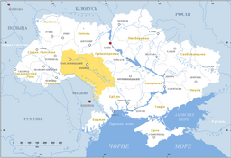
Podolia (yellow) in modern Ukraine
|
||
Podolia or Podilia (Ukrainian: Подíлля, Podillja, Russian: Подо́лье, Podolʹje, Turkish: Podolya, Polish: Podole, German: Podolien, Lithuanian: Podolė) is a historic region in Eastern Europe, located in the west-central and south-western parts of Ukraine and in northeastern Moldova (i.e. northern Transnistria). The term is derived from Old Slavic po, meaning "by/next to/along", and dol, "valley" (see dale).
The area is part of the vast East European Plain, confined by the Dniester River and the Carpathian arc in the southwest. It comprises an area of about 40,000 km2 (15,000 sq mi), extending for 320 km (200 mi) from northwest to southeast on the left bank of the Dniester. In the same direction run two ranges of relatively low hills separated by the Southern Bug, ramifications of the Avratynsk heights. The Podolian Upland, an elongated, up to 472 ft (144 m) high plateau stretches from the Western and Southern Bug rivers to the Dniester, includes hill countries and mountainous regions with canyon-like fluvial valleys.
Podolia lies east of historic Red Ruthenia, i.e. the eastern half of Galicia, beyond the Seret River, a tributary of the Dniester. In the northwest it borders on Volhynia. It is made up of the present-day Ukrainian Vinnytsia Oblast and southern and central Khmelnytskyi Oblast. The Podolian lands further include parts of adjacent Ternopil Oblast in the west and Kiev Oblast in the northeast. In the east it consists of the neighbouring parts of Cherkasy, Kirovohrad and Odessa Oblasts, as well as the northern half of Transnistria.
...
Wikipedia


