Plogonnec
|
Plogonnec Plogoneg |
||
|---|---|---|

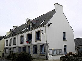
Town hall or Mairie
|
||
|
||
| Coordinates: 48°04′43″N 4°11′35″W / 48.0786°N 4.1931°WCoordinates: 48°04′43″N 4°11′35″W / 48.0786°N 4.1931°W | ||
| Country | France | |
| Region | Brittany | |
| Department | Finistère | |
| Arrondissement | Quimper | |
| Canton | Douarnenez | |
| Intercommunality | Quimper-Communauté | |
| Government | ||
| • Mayor (2014–2020) | Christian Kéribin | |
| Area1 | 54.14 km2 (20.90 sq mi) | |
| Population (2013)2 | 3,057 | |
| • Density | 56/km2 (150/sq mi) | |
| Time zone | CET (UTC+1) | |
| • Summer (DST) | CEST (UTC+2) | |
| INSEE/Postal code | 29169 /29180 | |
| Elevation | 12–286 m (39–938 ft) | |
|
1 French Land Register data, which excludes lakes, ponds, glaciers > 1 km² (0.386 sq mi or 247 acres) and river estuaries. 2Population without double counting: residents of multiple communes (e.g., students and military personnel) only counted once. |
||
1 French Land Register data, which excludes lakes, ponds, glaciers > 1 km² (0.386 sq mi or 247 acres) and river estuaries.
Plogonnec (Breton: Plogoneg) is a commune and small town in the Finistère department of Brittany in north-western France. It is about 13 km (8 mi) north west of Quimper and 10 km (6 mi) east of Douarnenez. The town is twinned with Llandysul in Wales.
The town is situated in a hilly area about 10 km (6 mi) inland from the fishing port of Douarnenez. Quimper is about 15 km (9 mi) to the south east and the N165 Brest to Nantes trunk road lies between Plogonnec and Quimper. The lowest part of the commune is the River Névet, the town is at an altitude of 130 m (427 ft) and the commune rises in the north to an altitude of 286 m (938 ft) on the slopes of the Montagne de Locronan. Panoramic views to the coast are available from the Montagne du Prieuré. The total area of the commune is around 3,200 ha (7,900 acres). Much of the land is agricultural but there are several protected areas of woodland. To the west is the extensive Bois du Nevet which offers opportunities for hiking.
The Seigneures of Névet headed a clan and were one of the oldest and most influential families in the Cornouaille. Their lands included both the west and east parts of the commune but the central part was under the control of the Princes of the House of Rohan under the direct authority of the Bishops of Cornouaille. At the end of the sixteenth century, the French Wars of Religion devastated the parish which was also affected by the Revolt of the Bonnets Rouges in 1675.
...
Wikipedia


