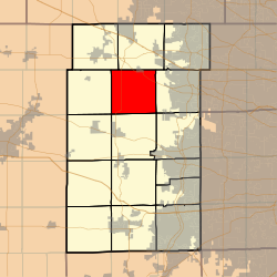
Plato Township, Kane County, Illinois
| Plato Township | |
|---|---|
| Township | |
 Location in Kane County |
|
 Kane County's location in Illinois |
|
| Coordinates: 42°01′34″N 88°25′52″W / 42.02611°N 88.43111°WCoordinates: 42°01′34″N 88°25′52″W / 42.02611°N 88.43111°W | |
| Country |
|
| State |
|
| County | Kane |
| Established | November 6, 1849 |
| Area | |
| • Total | 33.51 sq mi (86.8 km2) |
| • Land | 33.51 sq mi (86.8 km2) |
| • Water | 0 sq mi (0 km2) 0% |
| Elevation | 922 ft (281 m) |
| Population (2010) | |
| • Estimate (2016) | 6,356 |
| • Density | 184/sq mi (71/km2) |
| Time zone | CST (UTC-6) |
| • Summer (DST) | CDT (UTC-5) |
| ZIP codes | 60123, 60140, 60151, 60175 |
| FIPS code | 17-089-60365 |
Plato Township is one of sixteen townships in Kane County, Illinois, USA. As of the 2010 census, its population was 6,166 and it contained 2,182 housing units. It was originally named Homer Township; the name was changed to Plato on July 2, 1850.
According to the 2010 census, the township has a total area of 33.51 square miles (86.8 km2), all land.
(This list is based on USGS data and may include former settlements.)
The township contains these five cemeteries: Plato Center, L R Baker, North Plato, Udina and Washington Memorial.
...
Wikipedia
