Piraeus Prefecture
|
Piraeus Νομός Πειραιά |
|
|---|---|
| Former prefecture | |
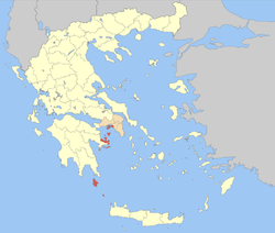
 Location of Piraeus in Greece |
|
 Location of municipalities within Piraeus Prefecture |
|
| Country | Greece |
| Periphery | Attica |
| Established | 1972 |
| Disestablished | 2010 |
| Capital | Piraeus |
| Subdivisions |
List
|
| Area | |
| • Total | 929 km2 (359 sq mi) |
| Area rank | 47th |
| Population (2001) | |
| • Total | 541,504 |
| • Rank | 3rd |
| • Density | 580/km2 (1,500/sq mi) |
| • Density rank | 2nd |
| Postal codes | 1xx xx, 801 xx |
| Area codes | 21x, 2736 |
| ISO 3166 code | GR-A4 |
| Website | nomarhiapeiraia.gr |
Piraeus Prefecture (Greek: Νομός Πειραιά or Νομός Πειραιώς) was one of the prefectures of Greece. It was part of the Attica region and the Athens-Piraeus super-prefecture (1994–2011). The capital of the prefecture was the city of Piraeus. As a part of the 2011 Kallikratis government reform, the prefecture was abolished, and its territory was divided into two regional units: Islands and Piraeus.
The prefecture covered the south-western part of the agglomeration of Athens, several islands in the Saronic Gulf (Salamis, Aegina, Agkistri, Poros, Hydra, Dokos, Spetses, Spetsopoula), Methana and Troizina on the Peloponnese peninsula, and the islands of Kythira and Antikythera south of the Peloponnese. An indication of the geographical diversity of the prefecture was the stark difference in population density between its seven mainland municipalities in the Athens metropolitan area, which have 9,244.2 inhabitants/km², and its detached outlying areas, which average only 85.83 inhabitants/km² (and most of these on Salamis Island, at 395.40/km², while the far-outlying parts have only 47.80/km²).
...
Wikipedia
