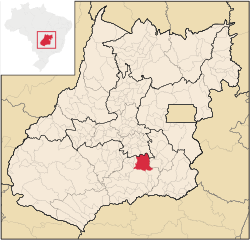
Piracanjuba
| Piracanjuba | |
|---|---|
| Municipality | |
 Location in Goiás state |
|
| Location in Brazil | |
| Coordinates: 17°08′S 49°01′W / 17.133°S 49.017°WCoordinates: 17°08′S 49°01′W / 17.133°S 49.017°W | |
| Country |
|
| Region | Central-West Region |
| State | Goiás |
| Microregion | Meia Ponte Microregion |
| Area | |
| • Total | 2,405.1 km2 (928.6 sq mi) |
| Elevation | 753 m (2,470 ft) |
| Population (2007) | |
| • Total | 23,310 |
| • Density | 9.7/km2 (25/sq mi) |
| Time zone | BRT/BRST (UTC-3/-2) |
| Postal code | 75640-000 |
| Website | www |
Piracanjuba is a municipality in southeastern Goiás state, Brazil. It is a big producer of orchids, milk products, and soybeans. Piracanjuba is also the name of a fish (Brycon orbignyanus) common to the waters of the Plata River basin.
Piracanjuba is located southeast of Goiânia. It is in the valley of the Piracanjuba River, which flows to south to join the Paranaíba. The important BR-153 highway lies 23 km. to the west.
Distances to important cities are: Goiânia, 85 km; Morrinhos, 76 km;, Caldas Novas, 62 km; and Brasília, 282 km. The main highways are Go-413, Go-147, Go-405 and BR-153, the interstate linking Goiânia with the state of Minas Gerais. There are municipal boundaries with Morrinhos, Caldas Novas, and Professor Jamil.
The origins of Piracanjuba go back to the nineteenth century when Padre Marinho began a settlement called Pouso Alto. A chapel was built in 1831 and by 1833 there were houses in the region. In 1855 it was elevated to district with the name Nossa Senhora da Abadia do Pouso Alto. In 1886 this name was changed to Piracanjuba. In 1907 once again the name was changed to Pouso Alto, only to return to Piracanjuba in 1943. Piracanjuba comes from the name of the river and a fish in the region. Later two districts, Cromínia and Mairipotaba, were dismembered to form separate municipalities.
The name "Piracanjuba" is derived from the fish with the same name (Triurobrycon lundii), which was once common in river waters of this region. ambientebrasil
...
Wikipedia

