Pioche
| Pioche, Nevada | |
|---|---|
| Unincorporated town | |
 |
|
| Location in the state of Nevada | |
| Coordinates: 37°56′29″N 114°26′56″W / 37.94139°N 114.44889°WCoordinates: 37°56′29″N 114°26′56″W / 37.94139°N 114.44889°W | |
| Country | United States |
| State | Nevada |
| County | Lincoln |
| Area | |
| • Total | 6.1 sq mi (15.9 km2) |
| • Land | 6.1 sq mi (15.9 km2) |
| • Water | 0 sq mi (0 km2) |
| Population (2010) | |
| • Total | 1,002 |
| • Density | 160/sq mi (63/km2) |
| Time zone | Pacific (PST) (UTC-8) |
| • Summer (DST) | PDT (UTC-7) |
| ZIP code | 89043 |
| FIPS code | 32-57400 |
| GNIS feature ID | 0854572 |
| Reference no. | 5 |
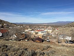
Pioche is an unincorporated town in Lincoln County, Nevada, United States, about 180 miles (290 km) northeast of Las Vegas. U.S. Route 93 is the main route to Pioche and bypasses the town center just to the east, with Nevada State Route 321 and Nevada State Route 322 providing direct access. Its elevation is 6,060 feet (1,850 m) above sea level. Pioche is the county seat of Lincoln County. It is named after François Louis Alfred Pioche, a San Francisco financier and land speculator originally from France. The town's population was 1,002 at the 2010 census.
The first modern settlement of the area occurred in 1864 with the opening of a silver mine. The settlers abandoned the area when local Indian tribes launched a series of raids and massacres. Recolonization launched in 1868, after this was stopped and François Pioche bought the town in 1869. By the early 1870s, it had grown to become one of the most important silver-mining towns in Nevada.
Because of the remoteness which had allowed the Indian raids to occur, the town had a reputation for being one of the roughest towns in the Old West. Local lore says 72 men were killed in gunfights before the first natural death occurred in the camp. This legend is immortalized by the creation of Boot Hill, now a landmark in the city.
Pioche has a cool semi-arid climate (Köppen BSk) bordering on a humid continental climate (Dfa/Dsa) due to its high altitude and exposure to rain-bearing winds. The high elevation means summers are much cooler than in Clark County, with temperatures of 100 °F or 37.8 °C reached upon only one afternoon every five years, and 90 °F or 32.2 °C reached only upon 23.1 afternoons. The hottest month has been July 2005 with a mean maximum of 93.0 °F or 33.9 °C, a record hot day of 105 °F (40.6 °C) on July 17, and nine days above the century form July 11 to 19. Although summers are mostly dry with mild nights, it is not unknown for “Arizona rains” to penetrate into Lincoln County during July and August, as happened in August 1945 when 5.01 inches (127.3 mm) of rain fell on a total of eleven “wet” days, and during August 1955 when seventeen days saw at least 0.01 inches or 0.3 millimetres of rain.
...
Wikipedia

