Pingcheng
|
Datong 大同市 |
||||||||||
|---|---|---|---|---|---|---|---|---|---|---|
| Prefecture-level city | ||||||||||
From top down, left to right: Datong panorama; Shanhua Temple; Huayan Temple; Yungang Grottoes; Tower at Lingyan Temple; Temple of Confucius (Wenmiao); Guandi Temple; Yinghui Gate of the City Wall
|
||||||||||
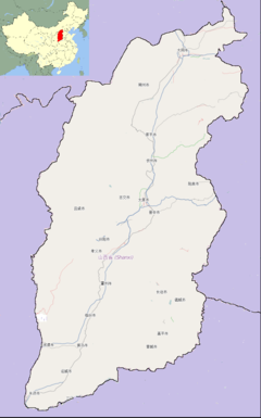
 Datong (red) in Shanxi (orange) |
||||||||||
| Coordinates: 40°05′N 113°18′E / 40.083°N 113.300°ECoordinates: 40°05′N 113°18′E / 40.083°N 113.300°E | ||||||||||
| Country | People's Republic of China | |||||||||
| Province | Shanxi | |||||||||
| Government | ||||||||||
| • Type | Prefecture-level city | |||||||||
| • Party Secretary | Zhang Jifu | |||||||||
| Area | ||||||||||
| • Prefecture-level city | 14,176 km2 (5,473 sq mi) | |||||||||
| • Urban | 2,080 km2 (800 sq mi) | |||||||||
| • Metro | 1,074 km2 (415 sq mi) | |||||||||
| Elevation | 1,042 m (3,419 ft) | |||||||||
| Population (2010 census) | ||||||||||
| • Prefecture-level city | 3,318,057 | |||||||||
| • Density | 230/km2 (610/sq mi) | |||||||||
| • Urban | 1,737,517 | |||||||||
| • Urban density | 840/km2 (2,200/sq mi) | |||||||||
| • Metro | 1,629,035 | |||||||||
| • Metro density | 1,500/km2 (3,900/sq mi) | |||||||||
| Time zone | China Standard (UTC+8) | |||||||||
| Postal code | 037000 | |||||||||
| Area code(s) | 0352 | |||||||||
| License Plates | 晋B | |||||||||
| Administrative division code | 140200 | |||||||||
| ISO 3166-2 | CN-14-02 | |||||||||
| Website | dt |
|||||||||
| Datong | |||||||||
| Chinese | |||||||||
|---|---|---|---|---|---|---|---|---|---|
| Literal meaning | Great Unity Great Togetherness |
||||||||
|
|||||||||
| Former names | |||||||||
| Pingcheng | |||||||||
|---|---|---|---|---|---|---|---|---|---|
| Traditional Chinese | |||||||||
| Simplified Chinese | |||||||||
| Literal meaning | Peaceful City County Pacified City County |
||||||||
|
|||||||||
| Xijing | |||||||||
| Chinese | |||||||||
| Literal meaning | Western Capital | ||||||||
|
|||||||||
Datong is a prefecture-level city in northern Shanxi Province in the People's Republic of China. It is located in a basin at an elevation of 1,040 metres (3,410 ft) and borders Inner Mongolia to the north and west and Hebei to the east. It had a population of 3,318,057 during the 2010 census, of whom 1,629,035 lived in the built-up area made of the three urban districts of Chengqu, Kuangqu and Nanjiao.
The area of present-day Datong was close to the Beidi ("Northern Barbarian") state of Dai, which was conquered by the Zhao clan of Jin in 457 BC. It was a frontier land between the agricultural Chinese and Beidi and the nomads of the Eurasian steppe (known to the Chinese as the Hu or Donghu). The area was well known for its trade in horses.
Pingcheng County formed part of the Qin commandery of Yanmen. It continued under the Han, who founded a site within present-day Datong in 200 BC following their victory against the Xiongnu nomads at the Battle of Baideng. Located near a pass to Inner Mongolia along the Great Wall, Pingcheng blossomed during the following period and became a stop-off point for camel caravans moving from China into Mongolia and beyond. It was sacked at the end of the Eastern Han. Pingcheng became the capital of Northern Wei from AD 398–494. The Yungang Grottoes were constructed during the later part of this period (460–494). During the mid to late 520s, Pingcheng was the seat of Northern Wei's Dai Commandery.
...
Wikipedia


