Piano dell'Acqua
| Piano dell'Acqua | |
|---|---|
| Frazione | |

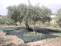
Olive tree in Piano dell'Acqua
|
|
| Location of Piano dell'Acqua in Italy | |
| Coordinates: 36°45′51.63″N 14°38′26.69″E / 36.7643417°N 14.6407472°ECoordinates: 36°45′51.63″N 14°38′26.69″E / 36.7643417°N 14.6407472°E | |
| Country |
|
| Region |
|
| Province | Ragusa (RG) |
| Comune | Chiaramonte Gulfi |
| Elevation | 353 m (1,158 ft) |
| Population (2011) | |
| • Total | 309 |
| Demonym(s) | Pianesi |
| Time zone | CET (UTC+1) |
| • Summer (DST) | CEST (UTC+2) |
| Postal code | 97012 |
| Dialing code | (+39) 0932 |
| Website | Official website |
Piano dell'Acqua (Sicilian: Cianu i l'Acqua) is a southern Italian village and hamlet (frazione) of Chiaramonte Gulfi, a municipality in the Province of Ragusa, Sicily. In 2011 it had a population of 3,172.
The name means water-plain, and until the late 1970s, beside the stream that crosses the village, there was an ancient washbasin in local limestone.
The village lies north of its province, close to the borders with the Province of Catania. It is 10 km north of Chiaramonte Gulfi and 17 km south of Licodia Eubea.
The local economy is mainly based on agriculture. Vineyards and olive trees dominate the landscape.
...
Wikipedia

