Phra Nakhon District
|
Phra Nakhon พระนคร |
|
|---|---|
| Khet | |

Arch celebrating King's 80th birthday, Ratchadamnoen Road
|
|
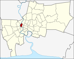
 Khet location in Bangkok |
|
| Coordinates: 13°45′52″N 100°29′57″E / 13.76444°N 100.49917°ECoordinates: 13°45′52″N 100°29′57″E / 13.76444°N 100.49917°E | |
| Country |
|
| Province | Bangkok |
| Seat | Wat Sam Phraya |
| Khwaeng | 12 |
| Area | |
| • Total | 5.536 km2 (2.137 sq mi) |
| Population (2013) | |
| • Total | 56,684 |
| • Density | 12,407.3/km2 (32,135/sq mi) |
| Time zone | ICT (UTC+7) |
| Postal code | 10200 |
| Geocode | 1001 |
Phra Nakhon (Thai: พระนคร; IPA: [pʰráʔ náʔkʰɔ̄ːn]) is one of the 50 districts (khet) of Bangkok, Thailand. It is the central district of Bangkok, including Rattanakosin Island. Neighboring districts are, starting from the north, clockwise: Dusit, Pom Prap Sattru Phai, Samphanthawong, and across the Chao Phraya River Thonburi, Bangkok Yai, Bangkok Noi, and Bang Phlat.
Phra Nakhon was also the name of Bangkok Province, until it was merged in 1972 with Thonburi to form the present day Bangkok metropolis.
The district is bounded by the Chao Phraya River to the west, Khlong Phadung Krung Kasem in the north, and Ratchadamnoen Road and Khlong Ong Ang to the east. The center of Bangkok, marked by the city pillar shrine (lak mueang), is in the district. Also surrounding the large open space of the Sanam Luang are the Grand Palace and Wat Phra Kaew, the National Museum in the former palace of the Vice King, and the main campus of Thammasat University as well as Silpakorn University.
...
Wikipedia
