Peso da Régua
| Peso da Régua | |||
|---|---|---|---|
| Municipality | |||

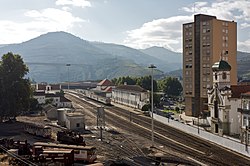
The railway station in Peso da Régua
|
|||
|
|||
 |
|||
| Coordinates: 41°9′55″N 7°46′35″W / 41.16528°N 7.77639°WCoordinates: 41°9′55″N 7°46′35″W / 41.16528°N 7.77639°W | |||
| Country |
|
||
| Region | Norte | ||
| Subregion | Douro | ||
| Intermunic. comm. | Douro | ||
| District | Vila Real | ||
| Parishes | 8 | ||
| Government | |||
| • President | Nuno Manuel Sousa Pinto de Carvalho Gonçalves (PSD-PPD) | ||
| Area | |||
| • Total | 94.86 km2 (36.63 sq mi) | ||
| Elevation | 255 m (837 ft) | ||
| Population (2011) | |||
| • Total | 17,131 | ||
| • Density | 180/km2 (470/sq mi) | ||
| Time zone | WET/WEST (UTC+0/+1) | ||
| Postal code | 5054 | ||
| Area code | 254 | ||
| Website | http://www.cm-pesoregua.pt | ||
Peso da Régua (Portuguese pronunciation: [ˈpezu ðɐ ˈʁɛɣwɐ]), commonly known as Régua, is a municipality in northern Portugal, in the district of Vila Real. The population in 2011 was 17,131 (of which approximately 10,000 are in the town of Régua), in an area of 94.86 km2 (36.63 sq mi) km².
Peso da Régua was inhabited by Roman and barbarian invasions during the early part of the settled history. Its name, as historians have suggested, developed from a few places: first, the name Vila Reggula a Roman estate that at one time existed near the historic centre; others suggest it originated from the word récua (the ships that plied the waters along the Douro); or derived the word reguengo (a designation for lands that were attributed to the monarchy). Peso da Régua may also have its origin in the word regra (English: rule), alluding to the hereditary rights of descendents achieved through forals. This theory is based on the donated of lands by Counts Henrique and Hugo in 1093, which were transferred to Egas Moniz. It is likely that this rule gave origin to the word Régoa, and later Régua. In relation to the first word, Peso, there are two opinions on its origin: the first, defends the it was derived from the place where the weighing of goods existed, or where taxes were levied; or, secondly, that the word was probably used to define the placed where animals were fed (Portuguese: pensado), or Penso.
Peso de Régua received its foral from King Sancho I, who conferred on the locality of Godim the municipal charter.
On 3 February 1837, Peso da Régua was elevated to the status of vila (English: town), which included the annexed municipality of Godim, the civil parishes of Godim, Loureiro, Fontelas, Moura Morta and Sedielos.
Its important role as municipality only achieved its zenith in 1836, after the Marquess of Pombal designated the Douro, its vineyards and wine, as a quality brand for export. This was helped through the creation of Companhia Geral das Vinhas do Alto Douro, in 1756, which delimited the vineyards of the Douro Valley by granite markers (Portuguese: Marcos de Feitora) to regulate the vineyards and wines produced. After this point, through commercialization and centralization, Régoa began to become the centre of the region.
...
Wikipedia


