Pennsylvania Route 62 (1920s)
| PA Route 100 | |||||||
|---|---|---|---|---|---|---|---|
 |
|||||||
| Route information | |||||||
| Maintained by PennDOT | |||||||
| Length: | 59.409 mi (95.610 km) | ||||||
| Existed: | 1932 – present | ||||||
| Major junctions | |||||||
| South end: |
|
||||||
|
|
|||||||
| North end: |
|
||||||
| Location | |||||||
| Counties: | Chester, Montgomery, Berks, Lehigh | ||||||
| Highway system | |||||||
|
|||||||
| PA Route 62 | |
|---|---|
| Location: | Chadds Ford – Pleasant Corners |
| Existed: | 1927–1932 |
|
PA Route 100 Truck |
|
|---|---|
| Location: | Macungie |
| Length: | 3.1 mi (5.0 km) |
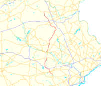
Pennsylvania Route 100 (PA 100) is a 59.4-mile (95.6 km) long state highway in the U.S. state of Pennsylvania that runs from U.S. Route 202 (US 202) near West Chester north to PA 309 in Pleasant Corners. The route runs between the western suburbs of Philadelphia and the Lehigh Valley region of the state, serving Chester, Montgomery, Berks, and Lehigh counties. PA 100 intersects several important highways including US 30 in Exton, the Pennsylvania Turnpike (Interstate 76, I-76) near Lionville, US 422 near Pottstown, US 222 in Trexlertown, and I-78/US 22 in Fogelsville. PA 100 has several sections which are multi-lane divided highway with some interchanges, including between US 202 and the Pennsylvania Turnpike in Chester County, between south of Pottstown and New Berlinville, and between Trexlertown and Fogelsville.
...
Wikipedia

