Penetanguishene
| Penetanguishene | |
|---|---|
| Town (lower-tier) | |
| Town of Penetanguishene Ville de Penetanguishenne |
|

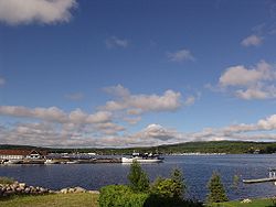
Town docks on Penetanguishene Bay.
|
|
| Coordinates: 44°46′N 79°56′W / 44.767°N 79.933°WCoordinates: 44°46′N 79°56′W / 44.767°N 79.933°W | |
| Country |
|
| Province |
|
| County | Simcoe |
| Incorporated | February 22, 1882 |
| Government | |
| • Mayor | Gerry Marshall |
| • MPs | Bruce Stanton |
| • MPPs | Patrick Brown |
| Area | |
| • Land | 25.58 km2 (9.88 sq mi) |
| Population (2016) | |
| • Total | 8,962 |
| • Density | 350.3/km2 (907/sq mi) |
| Time zone | Eastern (EST) (UTC-5) |
| • Summer (DST) | EDT (UTC-4) |
| Postal code | L9M 0A2 to L9M 2J4 |
| Area code(s) | 705 |
| Website | www |
Penetanguishene ![]() i/pɛnᵻˈtæŋɡwᵻʃiːn/, sometimes shortened to Penetang, is a town in Simcoe County, Ontario, Canada. It is located on the southeasterly tip of Georgian Bay. Incorporated on February 22, 1882, this bilingual (French and English) community has a population of 8,962 in the Canada 2016 Census.
i/pɛnᵻˈtæŋɡwᵻʃiːn/, sometimes shortened to Penetang, is a town in Simcoe County, Ontario, Canada. It is located on the southeasterly tip of Georgian Bay. Incorporated on February 22, 1882, this bilingual (French and English) community has a population of 8,962 in the Canada 2016 Census.
The name Penetanguishene is believed to come from either the Wyandot or Abenaki via Ojibwe, meaning "land of the white rolling sands".
As early as AD 800, the Huron settled in semi-permanent villages in the area. The young French translator, Étienne Brûlé, was the first European to set foot in the Penetanguishene area, some time between 1610 and 1614.
...
Wikipedia

