Pembina River (North Dakota)
| Pembina River | |
| Rivière Pembina | |
|
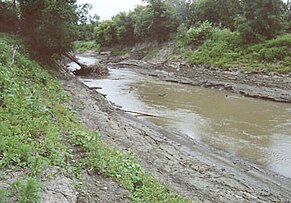
The Pembina River at Pembina, North Dakota, as viewed upstream from its mouth
|
|
| Countries |
|
|---|---|
| States/Provinces |
|
| Part of | Red River drainage basin |
| Source | Turtle Mountain (plateau) |
| - location | Manitoba, Canada |
| - coordinates |
49°05′06″N 100°03′05″W / 49.08500°N 100.05139°W (near Turtle Mountain) |
| Mouth | Red River of the North |
| - location | Pembina, North Dakota, United States |
| - coordinates | 48°57′59″N 97°14′21″W / 48.96639°N 97.23917°WCoordinates: 48°57′59″N 97°14′21″W / 48.96639°N 97.23917°W |
| Length | 319 mi (513 km) |
| Basin | 3,282 sq mi (8,500 km2) |
|
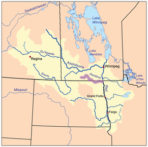
The Red River drainage basin, with the Pembina River highlighted
|
|
The Pembina River is a tributary of the Red River of the North, approximately 319 miles (513 km) long, in southern Manitoba in Canada and northeastern North Dakota in the United States. It drains an area (about 8500 square kilometers) of the prairie country along the Canada–US border, threading the Manitoba-North Dakota border eastward to the Red River. Via the Red River, Lake Winnipeg and the Nelson River, it is part of the watershed of Hudson Bay.
It rises in several streams on the eastern side of the Turtle Mountains on both sides of the international border. The streams converge near Neelin, Manitoba and flow initially northeast, then southeast along the west side of the Pembina Hills into Cavalier County in northeastern North Dakota. It flows east, just south of the border, past Walhalla and Neche. It joins the Red River from the west just south of Pembina, approximately 2 miles (3 km) south of the international border. It receives the Tongue River from the south approximately 2 miles (3 km) upstream from its mouth on the Red.
The main tributaries of the Pembina River are Badger Creek and Long River. Some of the numerous minor tributaries include the Mary Jane, Pilot, Crystal, and Snowflake Creeks. The Pembina River ranges in depth from 1.5 to 4 metres (4.9 to 13.1 ft) at mid-channel. The full width of the river is highly variable, ranging from 6 metres (20 ft) to as much as 40 metres (130 ft) in other areas. There are numerous wetlands and prairie potholes in this watershed.
...
Wikipedia


