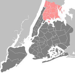
Pelham Parkway (neighborhood), Bronx
| Pelham Parkway | |
|---|---|
| Neighborhood of The Bronx | |

White Plains Road and Pelham Parkway South
|
|
| Location in New York City | |
| Coordinates: 40°51′27″N 73°51′23″W / 40.8575°N 73.856389°WCoordinates: 40°51′27″N 73°51′23″W / 40.8575°N 73.856389°W | |
| Country |
|
| State |
|
| City |
|
| Borough |
|
| Area | |
| • Total | 1.95 km2 (0.754 sq mi) |
| Population (2010) | |
| • Total | 30,073 |
| • Density | 15,000/km2 (40,000/sq mi) |
| Economics | |
| • Median income | $58,860 |
| Ethnicity | |
| • Hispanic | 39.4% |
| • Black | 10.7% |
| • White | 36.2% |
| • Asian | 11.3% |
| • Others | 2.4% |
| ZIP codes | 10461, 10462 |
| Area code | 718, 347, 646 |
Pelham Parkway is a working- and middle-class residential neighborhood geographically located in the center of the Bronx, a borough of New York City in the United States. The neighborhood is part of Bronx Community Board 11. Its boundaries, starting from the north and moving clockwise are: Waring Avenue to the north, the IRT Dyre Avenue Line tracks (5 train) to the east, Neill Avenue to the South, and Bronx River Parkway to the west. White Plains Road is the primary commercial thoroughfare through Bronx Park East. The local subway line is the IRT White Plains Road Line (2 5 trains) operating along White Plains Road. Zip codes include 10461 and 10462. The area is patrolled by the New York City Police Department 49th Precinct located at 2121 Eastchester Road in the Morris Park section of the Bronx.
Pelham Parkway is a major parkway in the neighborhood, which gives way to the neighborhood's name, originally called The Bronx and Pelham Parkway.
Based on data from the 2010 United States Census, the population of Pelham Parkway was 30,073, an increase of 67 (0.2%) from the 30,006 counted in 2000. Covering an area of 531.08 acres (214.92 ha), the neighborhood had a population density of 56.6 inhabitants per acre (36,200/sq mi; 14,000/km2).
...
Wikipedia


