Paso Robles, CA
| Paso Robles, California | ||
|---|---|---|
| City | ||
| City of El Paso de Robles | ||

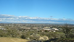
Overlooking Southern Paso Robles
|
||
|
||
| Nickname(s): Paso | ||
 Location in San Luis Obispo County and the state of California |
||
| Location in the United States | ||
| Coordinates: 35°38′27″N 120°39′14″W / 35.64083°N 120.65389°WCoordinates: 35°38′27″N 120°39′14″W / 35.64083°N 120.65389°W | ||
| Country |
|
|
| State |
|
|
| County | San Luis Obispo | |
| Incorporated | March 11, 1889 | |
| Government | ||
| • Type | Council-manager | |
| • Body | Paso Robles City Council | |
| • City manager | Tom Frutchey | |
| • City council |
Mayor Steven W. Martin, John Hamon, Fred Strong, Steve Gregory, and Jim Reed |
|
| • Assemblymember | Jordan Cunningham (R) | |
| • State senator | Bill Monning (D) | |
| Area | ||
| • Total | 19.425 sq mi (50.312 km2) | |
| • Land | 19.120 sq mi (49.522 km2) | |
| • Water | 0.305 sq mi (0.790 km2) 1.57% | |
| Elevation | 732 ft (223 m) | |
| Population (April 1, 2010) | ||
| • Total | 29,793 | |
| • Estimate (2013) | 30,857 | |
| • Density | 1,500/sq mi (590/km2) | |
| Time zone | Pacific (UTC−8) | |
| • Summer (DST) | PDT (UTC−7) | |
| ZIP codes | 93446, 93447 | |
| Area code | 805 | |
| FIPS code | 06-22300 | |
| GNIS feature IDs | 254139, 2410415 | |
| Website | prcity |
|
Paso Robles /pæsəˈroʊbleɪs/ (full name: El Paso de Robles 'The Pass of the Oaks') is a city in San Luis Obispo County, California, United States. Located on the Salinas River north of San Luis Obispo, California, the city is known for its hot springs, its abundance of wineries, production of olive oil, almond orchards, and for playing host to the California Mid-State Fair.
Paso Robles is located at 35°37′36″N 120°41′24″W / 35.62667°N 120.69000°W, approximately halfway between the cities of Los Angeles and San Francisco. Paso Robles is where the region of Southern California ends. The elevation of Paso Robles ranges from 675 to 1,100 feet (340 m), but the majority of the main downtown area of the city sits at about 740 feet (230 m) above sea level. According to the United States Census Bureau, the Paso Robles city limits contain a total land area of 19.4 sq mi (50.3 km2), 98.43% of it land and 1.57% of it water.
...
Wikipedia


