Parral, Mexico
| Parral | ||
|---|---|---|
| City | ||

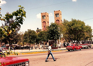
The Plaza Guillermo Baca in downtown Parral, showing the Searcher of Dreams Fountain and the Cathedral Shrine of Our Lady of Guadalupe, seat of the Diocese of Parral
|
||
|
||
| Location in Mexico | ||
| Coordinates: 26°56′N 105°40′W / 26.933°N 105.667°W | ||
| Country |
|
|
| State | Chihuahua | |
| Municipality | Hidalgo del Parral | |
| Founded | July 14 of 1631 | |
| Government | ||
| • Mayor | César Omar Dajlala Amaya (PRI) | |
| Elevation | 1,620 m (5,310 ft) | |
| Population (2010) | ||
| • Total | 104,836 | |
| Time zone | MST (UTC-7) | |
| • Summer (DST) | MDT (UTC-6) | |
| Postal Code | 31104 | |
| Area code(s) | 627 | |
| Climate | BSk | |
| Website | www |
|
Hidalgo del Parral, is a city and seat of the municipality of Hidalgo del Parral in the Mexican state of Chihuahua. It is located in the southern part of the state, 220 kilometres (140 mi) from the state capital, the city of Chihuahua, Chih. As of 2010, the city of Hidalgo del Parral had a population of 104,836, up from 101,147 at the 2005 census. The municipality includes numerous very small outlying communities in addition to the city. The city was founded as San José del Parral. The name was changed after independence from Spain, in honour of Fr Miguel Hidalgo, widely considered the 'Father of the Country'.
The city is one of the most European-fashioned in all Mexico, because of the historic presence of Spaniards and French.
According to legend, Juan Rangel de Biezma came here in 1629, picked up a rock on the “Cerro la Prieta” (La Prieta Hill), licked it and proclaimed “There is a mineral deposit here.” This deposit produced silver for 340 years.
Parral was once a bustling center for silver mining. As early as 1567, the silver mines at Santa Barbara were established in the territory of the Conchos Indians. However, in 1631, a vast new silver strike was made in what is now southern Chihuahua. Later, in 1640, it was declared "Capital of the World of Silver" by monarch Philip IV of Spain, at the very height of the Spanish Empire, that included territories in Eastern Asia, Italy, and the Low Countries.
The large area of southern Chihuahua inhabited by the Tarahumara people included the highway between the mining districts of Parral, Cusihuiriachic, and Chihuahua.Asarco managed the La Prieta mine until the boom ended in the early 1930s; the minerals that were extracted were sent to the United States for final processing and then shipped back to Mexico, the US and other markets. After the end of the silver mining boom, Parral was almost completely abandoned in the early 1930s (although the surrounding district continues to be mined for silver and base metals.) It is now a small city mainly dedicated to commerce.
...
Wikipedia


