Parker County
| Parker County, Texas | |
|---|---|

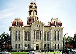
The Parker County courthouse in Weatherford
|
|
 Location in the U.S. state of Texas |
|
 Texas's location in the U.S. |
|
| Founded | 1856 |
| Seat | Weatherford |
| Largest city | Weatherford |
| Area | |
| • Total | 910 sq mi (2,357 km2) |
| • Land | 903 sq mi (2,339 km2) |
| • Water | 6.6 sq mi (17 km2), 0.7% |
| Population | |
| • (2010) | 116,927 |
| • Density | 129/sq mi (50/km²) |
| Congressional district | 12th |
| Time zone | Central: UTC-6/-5 |
| Website | www |
Parker County is a county located in the U.S. state of Texas. As of the 2010 census, its population was 116,927. The county seat is Weatherford. The county was created in 1855 and organized the following year. It is named for Isaac Parker, a state legislator who introduced the bill that established the county in 1855.
Parker County is included in the Dallas-Fort Worth-Arlington, TX Metropolitan Statistical Area.
According to the U.S. Census Bureau, the county has a total area of 910 square miles (2,400 km2), of which 903 square miles (2,340 km2) is land and 6.6 square miles (17 km2) (0.7%) is water. The county is intersected by the Brazos River.
Slipdown Mountain and Slipdown Bluff, at a height of 1,368 feet (417 m), are the highest points in Parker County. They are located just east of the Advance community, southwest of Poolville.
As of the census of 2003, there were 98,495 people, 31,131 households, and 24,313 families residing in the county. The population density was 98 people per square mile (38/km²). There were 34,084 housing units at an average density of 38 per square mile (15/km²). The racial makeup of the county was 83.17% White, 1.79% Black or African American, 0.67% Native American, 0.35% Asian, 0.02% Pacific Islander, 12.61% from other races, and 1.38% from two or more races. 7.02% of the population were Hispanic or Latino of any race.
...
Wikipedia
