Palmdale, California
| Palmdale, California | ||
|---|---|---|
| Charter city | ||
| City of Palmdale | ||

Palmdale, looking southeast toward the Antelope Valley Freeway and the San Gabriel Mountains
|
||
|
||
| Motto: "A Place To Call Home" | ||
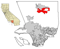
 Location of Palmdale in Los Angeles County, California |
||
| Location in the United States | ||
| Coordinates: 34°34′52″N 118°6′2″W / 34.58111°N 118.10056°WCoordinates: 34°34′52″N 118°6′2″W / 34.58111°N 118.10056°W | ||
| Country |
|
|
| State |
|
|
| County |
|
|
| Established | 1886 | |
| Incorporated | August 24, 1962 | |
| Government | ||
| • Type | Council-manager | |
| • Body |
City council: James Ledford Jr. (mayor), Austin Bishop, Dist-1, Steve Hofbauer, Dist-2, Laura Bettencourt, Dist-3, Juan Carillo, Dist-4 |
|
| Area | ||
| • City | 106.216 sq mi (275.099 km2) | |
| • Land | 105.961 sq mi (274.439 km2) | |
| • Water | 0.255 sq mi (0.660 km2) 0.24% | |
| Elevation | 2,657 ft (810 m) | |
| Population (April 1, 2010) | ||
| • City | 152,750 | |
| • Estimate (2013) | 157,161 | |
| • Rank |
6th in Los Angeles County 33rd in California |
|
| • Density | 1,400/sq mi (560/km2) | |
| • Metro | 12,828,837 | |
| Demonym(s) | Palmdalite | |
| Time zone | Pacific Time Zone (UTC-8) | |
| • Summer (DST) | PDT (UTC-7) | |
| ZIP codes | 93550–93552, 93590, 93591, 93599 | |
| Area code | 661 | |
| FIPS code | 06-55156 | |
| GNIS feature IDs | 1652769, 2411359 | |
| Website | www |
|
Palmdale is a city in the center of northern Los Angeles County in the U.S. state of California. The San Gabriel Mountains separate Palmdale from the City of Los Angeles.
On August 24, 1962, Palmdale became the first community in the Antelope Valley to incorporate. 47 years later, in November 2009, voters approved making it a charter city. Its population was 152,750 at the 2010 census, up from 116,670 at the 2000 census. Palmdale is the 33rd most populous city in California. In 2013, the Palmdale / Lancaster urban area had an estimated population of 513,547.
"Palmenthal", the first European settlement within the limits of Palmdale, was established as a village on April 20, 1886, by westward Lutheran travelers from the American Midwest, mostly of German and Swiss descent. According to area folklore, the travelers had been told they would know they were close to the ocean when they saw palm trees. Never actually having seen palm trees before, they mistook the local Joshua trees for palms and so named their settlement after them. (Palmenthal is German for Palms Valley.) According to David L. Durham Joshua trees were sometimes called yucca palms at the time, which was the reason for the name. The village was officially established upon the arrival of a post office on June 17, 1888.
By the 1890s (soon after the last of the indigenous antelopes, which the valley was named after, had died) farming families continued to migrate to Palmenthal and nearby Harold to grow grain and fruit. However, most of these settlers were unfamiliar with farming in a desert climate, so when the drought years occurred, most abandoned their settlement. By 1899, only one family was left in the original village. The rest of the settlers, including the post office, moved closer to the Southern Pacific railroad tracks. This new community was renamed Palmdale and was located where the present day civic center is. A railroad station was built along the tracks there. This railroad was operated by Southern Pacific and traveled between Los Angeles and San Francisco. The Wells Fargo stagecoach line that ran between San Francisco and New Orleans stopped there as well. The only remaining pieces of evidence of the original settlements of Palmenthal and Harold are the old Palmdale Pioneer cemetery located on the northeast corner of Avenue S and 20th Street East, recently acquired and restored by the city as part of a future historical park, and the old schoolhouse now relocated to McAdam Park.
...
Wikipedia


