Paint Rock, Texas
| Paint Rock, Texas | |
|---|---|
| Town | |

The Concho County Courthouse in Paint Rock
|
|
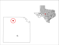
 Location of Paint Rock, Texas |
|
 |
|
| Coordinates: 31°30′28″N 99°55′24″W / 31.50778°N 99.92333°WCoordinates: 31°30′28″N 99°55′24″W / 31.50778°N 99.92333°W | |
| Country | United States |
| State | Texas |
| County | Concho |
| Area | |
| • Total | 1.7 sq mi (4.3 km2) |
| • Land | 1.7 sq mi (4.3 km2) |
| • Water | 0.0 sq mi (0.0 km2) |
| Elevation | 1,631 ft (497 m) |
| Population (2010) | |
| • Total | 273 |
| • Density | 166/sq mi (64.1/km2) |
| Time zone | Central (CST) (UTC-6) |
| • Summer (DST) | CDT (UTC-5) |
| ZIP code | 76866 |
| Area code(s) | 325 |
| FIPS code | 48-54636 |
| GNIS feature ID | 1364698 |
Paint Rock is a town in and the county seat of Concho County, Texas, United States. The population was 273 at the 2010 census, down from 320 at the 2000 census.
The town's name comes from Indian pictographs painted on cliffs overlooking the nearby Concho River. These pictographs cover nearly half a mile upstream from the town of Paint Rock. Some of the pictures painted on the rocks include animals, human figures, and handprints.
Paint Rock is located in northern Concho County at 31°30′28″N 99°55′24″W / 31.50778°N 99.92333°W (31.507777, -99.923277), along U.S. Route 83. Eden is 20 miles (32 km) to the south and Ballinger is 16 miles (26 km) to the north via US 83, while San Angelo is 32 miles (51 km) to the west via secondary roads.
According to the United States Census Bureau, the town of Paint Rock has a total area of 1.64 square miles (4.26 km2), all of it land.
A chapter titled "An Episode of Paint Rock" is devoted to the town in the 1895 book, A Lone Star Bo-Peep, and Other Tales of Texan Ranch Life written by Howard Seely. The chapter chronicles the week of May 5, 1883, in Paint Rock and features several local residents in the text.
As of the census of 2000, 320 people, 110 households, and 83 families resided in the town. The population density was 192.7 people per square mile (74.4/km2). The 126 housing units averaged 75.9 per square mile (29.3/km2). The racial makeup of the town was 77.19% White, 2.81% Native American, 19.69% from other races, and 0.31% from two or more races. Hispanics or Latinos were 28.44% of the population.
...
Wikipedia
